Category:Sepulveda Pass
Jump to navigation
Jump to search
| Object location | | View all coordinates using: OpenStreetMap |
|---|
pass over the Santa Monica Mountains connecting the Los Angeles Basin and the San Fernando Valley  | |||||
| Upload media | |||||
| Instance of | |||||
|---|---|---|---|---|---|
| Location | California, Pacific States Region | ||||
| Mountain range | |||||
| Elevation above sea level |
| ||||
 | |||||
English: Sepulveda Pass — a mountain pass in the Santa Monica Mountains, connecting the San Fernando Valley and the Westside, in Los Angeles, California.
- • Sepulveda Boulevard and the I−405 freeway use the pass.
Subcategories
This category has the following 2 subcategories, out of 2 total.
A
- American Jewish University (7 F)
S
- Skirball Cultural Center (11 F)
Media in category "Sepulveda Pass"
The following 10 files are in this category, out of 10 total.
-
 Los Angeles - Los Angeles (28254006385).jpg 2,294 × 2,169; 1.04 MB
-
 Los Angeles - Los Angeles (28254040035).jpg 2,105 × 2,672; 1.11 MB
-
 Los Angeles - Los Angeles (28254081005).jpg 2,448 × 3,264; 2.62 MB
-
 Los Angeles - Los Angeles (28254110045).jpg 2,448 × 3,264; 2.65 MB
-
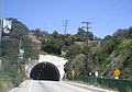 Sepulveda Boulevard Tunnel, Los Angeles.JPG 2,278 × 1,598; 796 KB
-
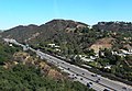
 The 405 in the Sepulveda Pass.JPG 3,264 × 1,602; 1.38 MB
-
 View from Getty Center Monorail 2.jpg 3,264 × 2,269; 2.45 MB
-
 View of the Valley from The 405.JPG 2,463 × 1,657; 1,006 KB
-
 Metro Red Line, Sepulveda Pass, San Fernando Valley.JPG 3,264 × 2,448; 1.78 MB
-
 Milken Community High School.JPG 3,264 × 2,448; 1.61 MB
.jpg)
.jpg)
.jpg)
.jpg)


