Category:Semi-detached houses in the East Riding of Yorkshire
Jump to navigation
Jump to search
Ceremonial counties of England: Buckinghamshire · Cambridgeshire · Cornwall · Cumbria · Devon · East Riding of Yorkshire · Essex · Gloucestershire · Greater London · Hampshire · Herefordshire · Hertfordshire · Kent · Lincolnshire · Norfolk · Northamptonshire · Nottinghamshire · Oxfordshire · Shropshire · South Yorkshire · Suffolk · Surrey · West Midlands · West Yorkshire ·
City-counties:
Former historic counties:
Other former counties:
City-counties:
Former historic counties:
Other former counties:
Media in category "Semi-detached houses in the East Riding of Yorkshire"
The following 47 files are in this category, out of 47 total.
-
 "Norwood", Chestnut Avenue, Hessle - geograph.org.uk - 363258.jpg 640 × 534; 195 KB
-
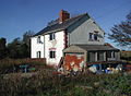
 1999 abandoned cottage, Sandhall, Skelton, Kilpin, East Yorkshire, England 1.jpg 4,512 × 2,977; 9.01 MB
-
 1999 abandoned cottage, Sandhall, Skelton, Kilpin, East Yorkshire, England 2.jpg 4,518 × 2,989; 9.99 MB
-
 1999 abandoned cottage, Sandhall, Skelton, Kilpin, East Yorkshire, England 3.jpg 4,509 × 2,984; 9.78 MB
-
 1999 abandoned cottage, Sandhall, Skelton, Kilpin, East Yorkshire, England 4.jpg 4,407 × 2,973; 9.21 MB
-

-
 Barrow Lane. Hessle - geograph.org.uk - 1277750.jpg 640 × 389; 73 KB
-
 Buttfield Road, Hessle - geograph.org.uk - 318909.jpg 632 × 381; 144 KB
-
 Cartwright Lane, Beverley, Yorkshire (geograph 4720914).jpg 2,800 × 2,119; 2.28 MB
-
 Coniston Lane, Thirtleby - geograph.org.uk - 551276.jpg 640 × 480; 79 KB
-
 Eastbourne Road, Hornsea - geograph.org.uk - 331049.jpg 640 × 431; 139 KB
-
 Edwardian House on Davenport Avenue Hessle.jpg 518 × 640; 119 KB
-

-

-
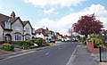
 Edwardian Houses on Ferriby Road, Hessle - geograph.org.uk - 1181642.jpg 640 × 512; 131 KB
-
 Frog Hall Cottage, Preston - geograph.org.uk - 549706.jpg 640 × 456; 112 KB
-
 High Battleburn - geograph.org.uk - 784437.jpg 640 × 471; 126 KB
-
 Houses on Kingston Road - geograph.org.uk - 1774367.jpg 640 × 471; 49 KB
-
 Houses on Main Street, Burstwick (geograph 6367454).jpg 640 × 417; 69 KB
-
 Houses on New Road, Hornsea - geograph.org.uk - 332422.jpg 640 × 428; 118 KB
-
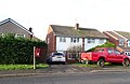
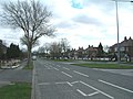 Kingston Road (B1232) - geograph.org.uk - 1774369.jpg 640 × 480; 75 KB
-
 Knedlington Road, Howden - geograph.org.uk - 576195.jpg 640 × 411; 114 KB
-
 Low Road semis - geograph.org.uk - 563761.jpg 640 × 450; 179 KB
-
 Malet Close Development, James Reckitt Avenue, Kingston upon Hull Dec23 Approach.jpg 4,176 × 2,784; 3.52 MB
-
 Malet Close Development, James Reckitt Avenue, Kingston upon Hull Dec23 Close View.jpg 4,176 × 2,784; 3.48 MB
-
 Malet Close Development, James Reckitt Avenue, Kingston upon Hull Dec23 Down Street.jpg 4,176 × 2,784; 3.44 MB
-
 Malet Close Development, James Reckitt Avenue, Kingston upon Hull Dec23 Ramps.jpg 4,176 × 2,784; 3.41 MB
-
 Malet Close Development, James Reckitt Avenue, Kingston upon Hull Dec23 Semi-Detached L.jpg 4,176 × 2,784; 3.48 MB
-

-

-
 Malet Close Development, James Reckitt Avenue, Kingston upon Hull Dec23 Side Entrance.jpg 4,176 × 2,784; 3.39 MB
-
 Malet Close Development, James Reckitt Avenue, Kingston upon Hull Dec23 Signage.jpg 2,784 × 4,176; 3.4 MB
-

-
 Malvern Crescent, Hull - geograph.org.uk - 543805.jpg 640 × 448; 85 KB
-
 Marsh Cottage, Keyingham - geograph.org.uk - 769051.jpg 640 × 453; 60 KB
-
 Moor Cottages, Humbleton - geograph.org.uk - 525154.jpg 640 × 420; 89 KB
-
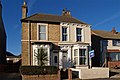
 No. 77 Ferriby Road, Hessle - geograph.org.uk - 1183340.jpg 640 × 430; 117 KB
-
 Semi-detached house, Beech View (geograph 5378548).jpg 640 × 426; 55 KB
-
 Southfield Lane Danthorpe.jpg 640 × 449; 86 KB
-
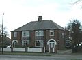
 Springfield Avenue, Brough - geograph.org.uk - 900137.jpg 640 × 458; 95 KB
-
 Stray Road, Sunk Island - geograph.org.uk - 323856.jpg 640 × 451; 70 KB
-
 Surbiton Close Developments, Kingston upon Hull Dec23.jpg 4,176 × 2,784; 3.51 MB
-
 Tansterne.jpg 640 × 468; 91 KB
-
 The Whitehouse - geograph.org.uk - 717896.jpg 640 × 486; 127 KB
-
 Valley Drive, Kirk Ella - geograph.org.uk - 1185808.jpg 540 × 640; 110 KB
-
 West Newton - geograph.org.uk - 561061.jpg 640 × 446; 72 KB
-
 West Newton.jpg 640 × 446; 80 KB


.jpg)


.jpg)

_-_geograph.org.uk_-_1774369.jpg)


.jpg)


