Category:Sea wall south of Canning Island
Jump to navigation
Jump to search
| Object location | | View all coordinates using: OpenStreetMap |
|---|
This is a category about listed building number 1205809. |
wall in Liverpool, Merseyside, England, UK  | |||||
| Upload media | |||||
| Instance of | |||||
|---|---|---|---|---|---|
| Location | Liverpool, Merseyside, North West England, England | ||||
| Heritage designation |
| ||||
 | |||||
Grade II listed section of sea wall between Canning Island and Hartley Quay, in granite, 1844 by Jesse Hartley.
Media in category "Sea wall south of Canning Island"
The following 2 files are in this category, out of 2 total.
-
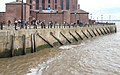 Sea wall south of Canning Island 1.jpg 4,992 × 3,126; 11.57 MB
-
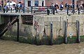 Sea wall south of Canning Island 2.jpg 4,740 × 3,036; 9.26 MB
