Category:Scotland photographs taken on 2008-05-31
Jump to navigation
Jump to search
Constituent countries of the United Kingdom: Scotland · Wales – British Crown dependencies: Bailiwick of Guernsey

Media in category "Scotland photographs taken on 2008-05-31"
The following 43 files are in this category, out of 43 total.
-
 A Track in Forest of Ae - geograph.org.uk - 832133.jpg 480 × 640; 210 KB
-

-

-
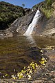
 Branches of Overtoun Burn meet - geograph.org.uk - 830941.jpg 640 × 480; 93 KB
-
 Breakwater at Methil - geograph.org.uk - 825032.jpg 640 × 421; 39 KB
-
 British Isles rural and coastal Scotland (2564521460).jpg 1,371 × 2,048; 1.26 MB
-
 British Isles rural and coastal Scotland (2564521938).jpg 2,048 × 1,371; 741 KB
-

-
 Calm morning, Tayvallich - geograph.org.uk - 829959.jpg 640 × 474; 96 KB
-
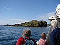
 Calmac Personnel - geograph.org.uk - 842970.jpg 640 × 480; 86 KB
-
 Camper in Overtoun Glen - geograph.org.uk - 831009.jpg 640 × 480; 98 KB
-
 Carn a' Garbh-choire - geograph.org.uk - 825012.jpg 640 × 433; 115 KB
-
 Castle Ban Motte - geograph.org.uk - 1725546.jpg 640 × 479; 333 KB
-
 Cattle grazing near Glenwhilt Farm - geograph.org.uk - 824106.jpg 640 × 480; 76 KB
-
 Cattle near Burnfoot - geograph.org.uk - 827020.jpg 640 × 480; 117 KB
-

-
 Ceapabhal cairn - geograph.org.uk - 837727.jpg 640 × 409; 63 KB
-
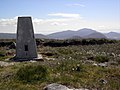 Ceapabhal trig point - geograph.org.uk - 837827.jpg 640 × 480; 81 KB
-
 Churchyard, Crichton Collegiate Church - geograph.org.uk - 827337.jpg 640 × 480; 101 KB
-
 Cioch na h-Oighe - geograph.org.uk - 837636.jpg 640 × 427; 295 KB
-
 Clach-dhruim Beag - geograph.org.uk - 824194.jpg 640 × 430; 97 KB
-
 Clachanbirnie Burn - geograph.org.uk - 835884.jpg 480 × 640; 264 KB
-
 Clatteringshaws Visitor Centre - geograph.org.uk - 824686.jpg 640 × 480; 124 KB
-
 Clett - Eastern 'shore' - geograph.org.uk - 825479.jpg 640 × 480; 76 KB
-
 Clett near Isay.jpg 640 × 480; 44 KB
-
 Coire Daingean - geograph.org.uk - 835899.jpg 640 × 427; 250 KB
-
 Coire Mhic Fhearachair - geograph.org.uk - 1179203.jpg 640 × 480; 87 KB
-
 Coire Mhic Fhearachair - geograph.org.uk - 1179214.jpg 640 × 480; 77 KB
-
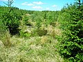
 Forest edge - geograph.org.uk - 831212.jpg 640 × 491; 100 KB
-
 Forest of Ae - geograph.org.uk - 832127.jpg 640 × 480; 234 KB
-
 Forest of Ae - geograph.org.uk - 832146.jpg 640 × 480; 167 KB
-
 Forest of Ae - geograph.org.uk - 832149.jpg 640 × 480; 216 KB
-
 Forest of Ae - geograph.org.uk - 832159.jpg 480 × 640; 220 KB
-
 Forest of Ae - geograph.org.uk - 832160.jpg 640 × 480; 157 KB
-
 Forest of Ae - geograph.org.uk - 832183.jpg 480 × 640; 221 KB
-
 Forest of Ae - geograph.org.uk - 835880.jpg 640 × 480; 211 KB
-
 Forest of Ae - geograph.org.uk - 835881.jpg 640 × 480; 206 KB
-
 Forest of Ae - geograph.org.uk - 835927.jpg 640 × 480; 231 KB
-
 Forest of Ae - geograph.org.uk - 835929.jpg 640 × 480; 228 KB
-
 Forest of Ae - geograph.org.uk - 835933.jpg 480 × 640; 185 KB
-
 Forest of Ae - geograph.org.uk - 835951.jpg 640 × 480; 196 KB
-
 Forest of Ae Cycle Trail - geograph.org.uk - 835949.jpg 480 × 640; 201 KB
-
 Lonely phone box (2564522432).jpg 2,048 × 1,371; 861 KB


.jpg)
.jpg)


.jpg)