Category:Schwammkalkfelsen Streitburg
Jump to navigation
Jump to search
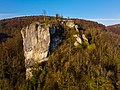
Naturdenkmal ND-04591 "Schwammkalkfelsmassiv mit vorgelagertem Streitberger Schild und Ruine" Geotop 474R018 "Schwammkalkfelsen Streitburg bei Streitberg"
| Object location | | View all coordinates using: OpenStreetMap |
|---|
Geotop in Landkreis Forchheim in Bavaria, Germany  | |||||
| Upload media | |||||
| Instance of | |||||
|---|---|---|---|---|---|
| Located in protected area | |||||
| Location | Wiesenttal, Forchheim, Upper Franconia, Bavaria, Germany | ||||
| Heritage designation | |||||
| Width |
| ||||
| Length |
| ||||
| Area |
| ||||
| Elevation above sea level |
| ||||
| official website | |||||
 | |||||
Media in category "Schwammkalkfelsen Streitburg"
The following 6 files are in this category, out of 6 total.
-
 2017 Schwammkalkfelsen Streitburg 01.jpg 5,115 × 3,410; 6.05 MB
-
 Burg Streitburg.jpg 2,048 × 1,536; 972 KB
-
 Streitberg 01.jpg 5,184 × 3,456; 7.4 MB
-
 Streitberg 03.jpg 3,456 × 5,184; 6.66 MB
-
 Streitberg Streitburg Ruine Luftbild-20211111-RM-152641.jpg 5,280 × 3,956; 15.93 MB
-
 Wiesenttal-Sreitberg-P5083363.jpg 4,608 × 3,456; 11.47 MB


Categories:
- Natural monuments in Landkreis Forchheim
- Streitburg
- Protected areas in Naturpark Fränkische Schweiz-Veldensteiner Forst
- Rocks in Naturpark Fränkische Schweiz-Veldensteiner Forst
- Geotopes in Naturpark Fränkische Schweiz-Veldensteiner Forst
- Geotopes in Landkreis Forchheim
- Geography of Streitberg
- Rocks in Landkreis Forchheim