Category:Schutzengelapotheke, Linz
Jump to navigation
Jump to search
| Object location | | View all coordinates using: OpenStreetMap |
|---|
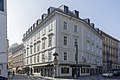
building in Linz, Austria  | |||||
| Upload media | |||||
| Instance of | |||||
|---|---|---|---|---|---|
| Location | Linz, Upper Austria, Austria | ||||
| Street address |
| ||||
| Heritage designation | |||||
 | |||||
Deutsch: Apotheke, Schutzengelapotheke - ehem. Freihaus Sprinzenstein
Media in category "Schutzengelapotheke, Linz"
The following 5 files are in this category, out of 5 total.
-
 Herrenstraße 2.JPG 4,000 × 3,000; 4.83 MB
-
 Immaculata Figur an der Schutzengelapotheke in Linz.jpg 3,483 × 5,224; 4.74 MB
-
 Linz Freihaus Spritzenstein rzezba.jpg 4,000 × 6,000; 6.11 MB
-
 Schutzengelapotheke, Linz 1.jpg 4,575 × 3,050; 2.56 MB
-
 Schutzengelapotheke, Linz 2.jpg 4,880 × 3,811; 4.68 MB


