Category:Schuitendiep 9 (Groningen)
Jump to navigation
Jump to search
| Object location | | View all coordinates using: OpenStreetMap |
|---|
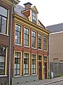
building in Groningen, Netherlands  | |||||
| Upload media | |||||
| Instance of | |||||
|---|---|---|---|---|---|
| Location | Groningen, Netherlands | ||||
| Located on street |
| ||||
| Heritage designation |
| ||||
 | |||||
|
This is a category about rijksmonument number 18676
|
| Address |
|
Media in category "Schuitendiep 9 (Groningen)"
The following 3 files are in this category, out of 3 total.
-
 Groningen Schuitendiep 9.JPG 2,448 × 3,264; 3.86 MB
-
 Voorgevel - Groningen - 20094310 - RCE.jpg 815 × 1,200; 248 KB
-
 Voorgevel - Groningen - 20094311 - RCE.jpg 1,188 × 1,200; 292 KB

