Category:School of L'Abergement-Clémenciat
Jump to navigation
Jump to search
| Object location | | View all coordinates using: OpenStreetMap |
|---|
 | |||||
| Upload media | |||||
| Instance of | |||||
|---|---|---|---|---|---|
| Industry |
| ||||
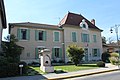
| Location | L'Abergement-Clémenciat, Ain, Auvergne-Rhône-Alpes, Metropolitan France, France | ||||
| Street address |
| ||||
| Owned by | |||||
| Inception |
| ||||
 | |||||
Media in category "School of L'Abergement-Clémenciat"
The following 7 files are in this category, out of 7 total.
-
 École Abergement Clémenciat 1.jpg 5,184 × 3,456; 6.31 MB
-
 École Abergement Clémenciat 2.jpg 5,184 × 3,456; 5.99 MB
-
 École Abergement Clémenciat 3.jpg 3,456 × 5,184; 6.59 MB
-
 École Abergement Clémenciat 4.jpg 5,184 × 3,456; 4.9 MB
-
 École Abergement Clémenciat 5.jpg 3,456 × 5,184; 6.51 MB
-
 École Abergement Clémenciat 6.jpg 5,184 × 3,456; 6.39 MB
-
 École Abergement Clémenciat 7.jpg 5,184 × 3,456; 7.53 MB


