Category:Schnebly Hill Formation
Jump to navigation
Jump to search
English: The Schnebly Hill Formation — a Permian red sandstone geologic formation in northeastern Yavapai County, and southwestern Coconino County, Arizona, Southwestern U.S.
- It is at the northwestern Mogollon Rim transition zone (Mogollon Plateau).
- Two canyon/valley regions contain extensive exposed formations — Oak Creek Canyon and Sycamore Canyon.
- The formation surrounds Sedona on the town's east, north, and west. The townsite of Sedona sits upon the Hermit Shale (Hermit Formation).
- Geology
- The Schnebly Hill Formation was formed at the north-(northwest perimeter) of the ancient, elongated, semi-elliptical, Pedregosa Basin, which extended southeastwards from Sedona, to south of New Mexico state region (northwest Chihuahua Desert region).
- Geologic associated layers/Members:
- Underlies--Coconino Sandstone, Permian, white cliffs
Unit--Schnebly Hill Formation-Permian, red cliffs & colorful landforms
Overlies--Hermit Shale-(Hermit Formation)- Permian, an eroded slope-former
- Underlies--Coconino Sandstone, Permian, white cliffs
Subcategories
This category has the following 5 subcategories, out of 5 total.
Media in category "Schnebly Hill Formation"
The following 10 files are in this category, out of 10 total.
-
 Atop Schebly Hill (5009965364).jpg 3,888 × 2,592; 7.34 MB
-
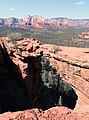 Devils Bridge, Sedona.jpg 2,304 × 3,114; 2.87 MB
-
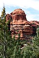
 Mitten Ridge (3910009307).jpg 3,264 × 2,448; 6.86 MB
-
 NPS wupatki-geologic-map-overview.jpg 4,546 × 2,512; 2.01 MB
-
 Oak Crk Canyon.jpg 2,048 × 3,072; 3.59 MB
-
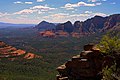 Red Rocks from Schnebly Hill (5009965702).jpg 3,888 × 2,592; 1.74 MB
-
 Red Rocks off Schnebly Hill (5009967994).jpg 3,888 × 2,592; 2.07 MB
-
 Sedona Arizona.jpg 2,340 × 1,576; 848 KB
-
 Sedona Brins Fire 2006.jpg 465 × 309; 70 KB
-
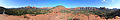 Vortex panoramicview sedona.jpg 5,226 × 864; 1.88 MB
.jpg)

.jpg)


.jpg)
.jpg)

