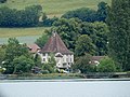
Category:Schlossspeicher (Hauptstrasse 57, Muntelier)
Jump to navigation
Jump to search
| Object location | | View all coordinates using: OpenStreetMap |
|---|
impressive building in Muntelier in the canton of Fribourg, Switzerland .JPG) | |||||
| Upload media | |||||
| Instance of | |||||
|---|---|---|---|---|---|
| Part of | |||||
| Location | Muntelier, See District, Canton of Fribourg, Switzerland | ||||
| Street address |
| ||||
| Heritage designation | |||||
 | |||||
Media in category "Schlossspeicher (Hauptstrasse 57, Muntelier)"
The following 3 files are in this category, out of 3 total.
-
 Muntelier Hauptstrasse 57 vom See aus (cropped).JPG 3,686 × 2,765; 3.92 MB
-
 Muntelier Hauptstrasse 57 vom See aus.JPG 4,608 × 3,456; 6.32 MB
-
 Muntelier Hauptstrasse 57.jpg 2,085 × 1,710; 1.61 MB

