Category:Schlosspark Baruth
Jump to navigation
Jump to search
| Object location | | View all coordinates using: OpenStreetMap |
|---|
 | |||||
| Upload media | |||||
| Instance of | |||||
|---|---|---|---|---|---|
| Location | Malschwitz, Bautzen District, Saxony, Germany | ||||
| Street address |
| ||||
| Heritage designation | |||||
| Inception |
| ||||
 | |||||
Subcategories
This category has the following 2 subcategories, out of 2 total.
G
- Grundschule Baruth (4 F)
S
- Schlossteich Baruth (3 F)
Media in category "Schlosspark Baruth"
The following 8 files are in this category, out of 8 total.
-
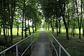
 Malschwitz Baruth - Am Park - Schlosspark 01 ies.jpg 5,616 × 3,744; 23.52 MB
-
 Malschwitz Baruth - Am Park - Schlosspark 02 ies.jpg 3,744 × 5,616; 11.6 MB
-
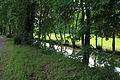
 Malschwitz Baruth - Am Park - Schosspark+Löbauer Wasser 01 ies.jpg 5,616 × 3,744; 16.86 MB
-
 Malschwitz Baruth - Am Park - Schosspark+Löbauer Wasser 02 ies.jpg 5,616 × 3,744; 19.94 MB
-
 Malschwitz Baruth - Am Park - Schosspark+Löbauer Wasser 03 ies.jpg 5,616 × 3,744; 19.96 MB
-
 Malschwitz Baruth - Am Park - Schosspark+Löbauer Wasser+Lindenallee 01 ies.jpg 5,616 × 3,744; 20.9 MB
-
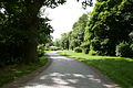 Malschwitz Baruth - Am Park 02 ies.jpg 3,888 × 2,592; 1.96 MB
-
 Malschwitz Baruth - Am Park+Schlosspark 01 ies.jpg 5,616 × 3,744; 20.62 MB


