Category:Schloss Grube
Jump to navigation
Jump to search
| Object location | | View all coordinates using: OpenStreetMap |
|---|
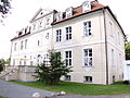
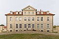
manor house in Bad Wilsnack, Brandenburg state, Germany  | |||||
| Upload media | |||||
| Instance of | |||||
|---|---|---|---|---|---|
| Location | Grube, Bad Wilsnack, Prignitz District, Brandenburg, Germany | ||||
| Heritage designation | |||||
 | |||||
This is the category of the Brandenburger Baudenkmal (cultural heritage monument) with the ID 09160156 (Wikidata)
|
Media in category "Schloss Grube"
The following 7 files are in this category, out of 7 total.
-
 Grube Schloss 10.JPG 3,000 × 4,000; 2.86 MB
-
 Grube Schloss 11.JPG 3,000 × 4,000; 2.95 MB
-
 Grube Schloss 5.JPG 4,000 × 3,000; 3.1 MB
-
 Grube Schloss 7.JPG 4,000 × 3,000; 3.09 MB
-
 Grube Schloss 8.JPG 4,000 × 3,000; 3.14 MB
-
 Prignitz 07-13 img08 Grube Schloss.jpg 4,576 × 3,002; 3.53 MB
-
 Schloss Grube.jpg 2,752 × 1,968; 1.82 MB


