Category:Schloss Frankenreuth
Jump to navigation
Jump to search
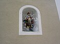
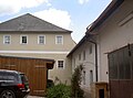
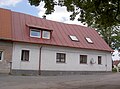
This is the category of the Bavarian Baudenkmal (cultural heritage monument) with the ID D-3-74-164-23 (Wikidata)
|
| Object location | | View all coordinates using: OpenStreetMap |
|---|
building in Waidhaus, Upper Palatinate, Germany  | |||||
| Upload media | |||||
| Instance of | |||||
|---|---|---|---|---|---|
| Location | Frankenreuth, Waidhaus, Neustadt an der Waldnaab, Upper Palatinate, Bavaria, Germany | ||||
| Street address |
| ||||
| Heritage designation | |||||
| Said to be the same as | Cultural heritage D-3-6341-0006 in Waidhaus | ||||
 | |||||
Media in category "Schloss Frankenreuth"
The following 19 files are in this category, out of 19 total.
-
 FrankenreuthSchloss 01.jpg 2,304 × 1,704; 886 KB
-
 FrankenreuthSchloss 02.jpg 2,304 × 1,704; 837 KB
-
 FrankenreuthSchloss 03.jpg 2,304 × 1,704; 883 KB
-
 FrankenreuthSchloss 04.jpg 2,304 × 1,704; 850 KB
-
 FrankenreuthSchloss 05.jpg 2,304 × 1,704; 867 KB
-
 FrankenreuthSchloss 06.jpg 2,304 × 1,704; 899 KB
-
 FrankenreuthSchloss 07.jpg 2,304 × 1,704; 705 KB
-
 FrankenreuthSchloss 08.jpg 2,304 × 1,704; 594 KB
-
 FrankenreuthSchloss 09.jpg 2,304 × 1,704; 820 KB
-
 FrankenreuthSchloss 10.jpg 2,304 × 1,704; 785 KB
-
 FrankenreuthSchloss 11.jpg 2,304 × 1,704; 608 KB
-
 FrankenreuthSchloss 12.jpg 2,304 × 1,704; 813 KB
-
 FrankenreuthSchloss 13.jpg 2,304 × 1,704; 901 KB
-
 FrankenreuthSchloss 14.jpg 2,304 × 1,704; 686 KB
-
 FrankenreuthSchloss 15.jpg 2,304 × 1,704; 850 KB
-
 FrankenreuthSchloss 16.jpg 2,304 × 1,704; 753 KB
-
 FrankenreuthSchloss 17.jpg 2,304 × 1,704; 890 KB
-
 FrankenreuthSchloss 18.jpg 2,304 × 1,704; 744 KB
-
 Schloss Frankenreuth.PNG 586 × 302; 413 KB


