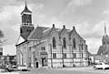
Category:Schildkerk
Jump to navigation
Jump to search
| Object location | | View all coordinates using: OpenStreetMap |
|---|
church building in Rijssen-Holten, Netherlands .jpg) | |||||
| Upload media | |||||
| Instance of | |||||
|---|---|---|---|---|---|
| Location | Rijssen, Overijssel, Netherlands | ||||
| Street address |
| ||||
| Located on street |
| ||||
| Architect |
| ||||
| Heritage designation |
| ||||
| Significant event |
| ||||
| Maximum capacity |
| ||||
 | |||||
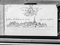
Nederlands: Schildkerk of Grote Kerk - anno 16e eeuw
|
This is a category about rijksmonument number 33026
|
| Address |
|
Subcategories
This category has only the following subcategory.
Media in category "Schildkerk"
The following 67 files are in this category, out of 67 total.
-
 Avondmaalsbeker naar tekening van G.J.ter Kuile - Rijssen - 20187638 - RCE.jpg 883 × 1,200; 147 KB
-
 Exterieur OVERZICHT OOSTGEVEL - Rijssen - 20297239 - RCE.jpg 1,195 × 1,200; 325 KB
-
 Exterieur OVERZICHT WESTGEVEL - Rijssen - 20297238 - RCE.jpg 1,200 × 956; 277 KB
-
 Exterieur OVERZICHT ZUIDGEVEL, OOSTGEVEL - Rijssen - 20297232 - RCE.jpg 1,200 × 1,200; 325 KB
-
 Interieur naar het zuid-oosten - Rijssen - 20187630 - RCE.jpg 883 × 1,200; 188 KB
-
 Interieur naar het zuid-westen - Rijssen - 20187631 - RCE.jpg 889 × 1,200; 150 KB
-
 Interieur naar het zuid-westen - Rijssen - 20187632 - RCE.jpg 871 × 1,200; 160 KB
-
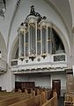 Interieur, aanzicht orgel, orgelnummer 1267 - Rijssen - 20370690 - RCE.jpg 837 × 1,200; 157 KB
-
 Interieur, doopvont - Rijssen - 20187637 - RCE.jpg 851 × 1,200; 225 KB
-

-

-

-

-

-

-

-
 Interieur, resten van schilderingen in het koor - Rijssen - 20401216 - RCE.jpg 1,192 × 1,200; 250 KB
-
 JV1060788.jpg 4,000 × 3,000; 3.09 MB
-
 JV1060789.jpg 2,761 × 3,981; 2.15 MB
-
 JV1070088.jpg 4,008 × 3,008; 3.57 MB
-
 JV1090082.jpg 3,000 × 4,000; 4.64 MB
-
 JV1090083.jpg 3,000 × 4,000; 4.73 MB
-
 JV1090089.jpg 3,000 × 4,000; 4.68 MB
-
 JV1100704A.jpg 4,000 × 3,000; 4.03 MB
-
 JV1100779.jpg 4,000 × 3,000; 4.76 MB
-
 JV1110805B.jpg 4,008 × 3,008; 3.93 MB
-
 JV1110814.jpg 4,000 × 3,000; 4.62 MB
-
 JV1160781A 01.jpg 3,497 × 1,965; 3.01 MB
-
 JV1160781A 02.jpg 2,609 × 3,065; 3.24 MB
-
 Kerk naar het noord-oosten - Rijssen - 20187620 - RCE.jpg 1,200 × 886; 217 KB
-
 Kerk naar het noord-westen - Rijssen - 20187618 - RCE.jpg 1,200 × 881; 241 KB
-
 Kerk naar het noord-westen - Rijssen - 20187623 - RCE.jpg 883 × 1,200; 267 KB
-
 Kerk naar het noorden - Rijssen - 20187621 - RCE.jpg 1,200 × 883; 283 KB
-
 Kerk naar het noorden - Rijssen - 20187626 - RCE.jpg 1,200 × 857; 269 KB
-
 Kerk naar het oosten - Rijssen - 20187616 - RCE.jpg 886 × 1,200; 200 KB
-
 Kerk naar het zuid-oosten - Rijssen - 20187624 - RCE.jpg 887 × 1,200; 271 KB
-
 Kerk naar het zuid-oosten - Rijssen - 20187625 - RCE.jpg 1,200 × 824; 239 KB
-
 Kerk naar het zuid-oosten - Rijssen - 20187627 - RCE.jpg 1,200 × 820; 297 KB
-
 Kerk naar het zuid-westen - Rijssen - 20187617 - RCE.jpg 873 × 1,200; 222 KB
-
 Kerk naar het zuid-westen - Rijssen - 20187619 - RCE.jpg 921 × 1,200; 292 KB
-
 Kerk naar het zuid-westen - Rijssen - 20187622 - RCE.jpg 873 × 1,200; 217 KB
-
 Netherlands, Rijssen, Schildkerk and Kerkstraat.jpg 4,032 × 2,268; 3.07 MB
-
 Netherlands, Rijssen, Schildkerk or Grote Kerk (01).jpg 3,724 × 3,256; 4.18 MB
-
 Netherlands, Rijssen, Schildkerk or Grote Kerk (02).jpg 3,705 × 3,358; 4.09 MB
-
 Noord-zijde - Rijssen - 20187643 - RCE.jpg 815 × 1,200; 186 KB
-
 Ontdekte ingang noord-zijde - Rijssen - 20187629 - RCE.jpg 882 × 1,200; 301 KB
-
 Resten van schilderingen in koor - Rijssen - 20187646 - RCE.jpg 1,188 × 1,200; 350 KB
-
 Resten van schilderingen in koor - Rijssen - 20187647 - RCE.jpg 1,197 × 1,200; 265 KB
-
 Resten van schilderingen in koor - Rijssen - 20187648 - RCE.jpg 1,192 × 1,200; 354 KB
-
 Resten van schilderingen in koor - Rijssen - 20187649 - RCE.jpg 1,197 × 1,200; 330 KB
-
 Resten van schilderingen in koor - Rijssen - 20187650 - RCE.jpg 1,190 × 1,200; 279 KB
-
 Rococogestoelte - Rijssen - 20187636 - RCE.jpg 887 × 1,200; 138 KB
-
 Schildkerk (1).jpg 1,896 × 1,869; 1.05 MB
-
 Schildkerk (2).jpg 3,000 × 4,000; 4.83 MB
-
 Schildkerk of Grote Kerk Rijssen 1.jpg 4,896 × 3,672; 7.09 MB
-
 Schildkerk of Grote Kerk Rijssen 2.jpg 4,896 × 3,672; 6.57 MB
-
 Schildkerk Rijssen 3.jpg 4,004 × 2,884; 2.02 MB
-
 Skeeldkoarke in n duuster.jpg 640 × 452; 245 KB
-
 Skeeldkoarke.jpg 612 × 612; 89 KB
-
 Toren aanzicht - Rijssen - 20187642 - RCE.jpg 817 × 1,200; 192 KB
-
 Travee aan de noord-zijde - Rijssen - 20187628 - RCE.jpg 884 × 1,200; 317 KB
-
 Vooraanzicht - Rijssen - 20187645 - RCE.jpg 798 × 1,200; 214 KB
-
-

-
 Zilveren avondmaalsbekers - Rijssen - 20187641 - RCE.jpg 914 × 1,200; 81 KB
-
 Zilveren avondmaalsbekers - Rijssen - 20373213 - RCE.jpg 907 × 1,200; 93 KB
-
 Zuid-zijde - Rijssen - 20187644 - RCE.jpg 1,200 × 806; 199 KB


.jpg)


.jpg)
.jpg)


