Category:Sattelkopf
Jump to navigation
Jump to search
mountain in the Allgäu Alps  | |||||
| Upload media | |||||
| Instance of | |||||
|---|---|---|---|---|---|
| Made from material | |||||
| Location | |||||
| Mountain range |
| ||||
| Topographic prominence |
| ||||
| Topographic isolation |
| ||||
| Elevation above sea level |
| ||||
 | |||||
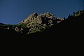
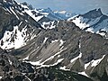
Deutsch: Der Sattelkopf ist ein 2097 Meter hoher Berg in den Allgäuer Alpen, über den die Grenze zwischen Deutschland (Bayern) und Österreich (Tirol) verläuft.
English: The Sattelkopf (2097 m) is a mountain in the Allgäu Alps, situated on the border between Germany (Bavaria) and Austria (Tyrol).
Media in category "Sattelkopf"
The following 10 files are in this category, out of 10 total.
-
 Felswände unterhalb der Lärchwand - panoramio.jpg 2,048 × 1,371; 637 KB
-
 Laufbichlkirche - panoramio.jpg 4,592 × 3,056; 4.31 MB
-
 Oberstdorf vom Sattelkopf - geo.hlipp.de - 1309.jpg 640 × 434; 93 KB
-
 Sattelkoepfe vom Erzbergtal.jpg 1,464 × 976; 76 KB
-
 Sattelkopf from Northeast.JPG 3,840 × 2,160; 1.59 MB
-
 Sattelkopf from Northwest.JPG 3,840 × 2,160; 1.72 MB
-
 Sattelkopf from South.JPG 4,000 × 3,000; 2.28 MB
-
 Sattelkopf Glasfelderkopf from North.JPG 3,840 × 2,160; 1.57 MB
-
 Sattelkopf.JPG 3,264 × 2,448; 4.29 MB
-
 Schaenzlekopf Schaenzlespitze.JPG 3,264 × 2,448; 3.89 MB


Categories:
- Mountains of Landkreis Oberallgäu
- Mountains of Allgäu Alps in Bavaria
- Mountains of Allgäu Alps in Tyrol (state)
- Hochvogel- und Rosszahngruppe
- 2090s mountains of Tyrol (state)
- 2090s mountains of Swabia (Bavaria)
- Borders of Austria-Germany
- Mountains of Austria by name
- Mountains of Germany by name
- International mountains