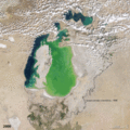
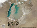
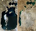
Category:Satellite pictures of Aral Sea
Jump to navigation
Jump to search
Subcategories
This category has the following 2 subcategories, out of 2 total.
I
- Photos of Aral Sea from ISS (273 F)
N
Media in category "Satellite pictures of Aral Sea"
The following 86 files are in this category, out of 86 total.
-
 AralSeaAug1964-keyhole.jpg 1,556 × 1,554; 1.11 MB
-
 Aral sea 1985 from STS.jpg 606 × 599; 132 KB
-
 Aral sea 1989 250m.jpg 784 × 1,386; 312 KB
-
 Aral Sea 1997 from STS cropped.jpg 3,200 × 2,400; 921 KB
-
 Aral1.jpg 612 × 480; 40 KB
-
 AralSea(1997) NASA STS085-503-119.jpg 5,209 × 4,088; 14.39 MB
-
 AralSea.A2001165.0710.500m.jpg 1,200 × 1,600; 273 KB
-
 NizinaTuranska2001grudzien.jpg 4,800 × 3,600; 2.19 MB
-
 Aral sea from space in 2002.jpg 2,400 × 3,200; 736 KB
-
 Aral Nasa.jpg 1,600 × 2,000; 460 KB
-
 AralSea.A2003283.0705.500m.jpg 1,200 × 1,600; 382 KB
-
 Aral-u.Saryk.See.png 800 × 1,074; 1.24 MB
-
 Karte aralsee.jpg 800 × 1,074; 185 KB
-
 AralSea200606.jpg 1,600 × 2,000; 406 KB
-
 Aral Sea 05 October 2008.jpg 1,179 × 1,530; 237 KB
-
 Aral Sea April 10, 2008.jpg 841 × 1,079; 382 KB
-
 AralSea A20081005.jpg 2,400 × 3,200; 1.12 MB
-
 AralSea.A2008085.0910.1km.jpg 900 × 700; 142 KB
-
 Aral sea 20090503.jpg 2,000 × 2,000; 934 KB
-
 Aral Sea Continues to Shrink, August 2009.jpg 2,000 × 2,000; 889 KB
-
 AralSea A2009169 0715 250m.jpg 2,400 × 3,200; 1.03 MB
-
 AralSea AMO 200907 lrg.jpg 2,400 × 3,200; 863 KB
-
 Kath und Gurgandsch.jpg 746 × 1,024; 125 KB
-
 Khwarazm oasis.jpg 745 × 1,024; 137 KB
-
 Khwarazm.jpg 814 × 1,117; 183 KB
-
 خوارزم.jpg 746 × 1,024; 134 KB
-
 AralSeaModis.jpg 2,400 × 1,800; 730 KB
-
 Mar de Aral (NASA Terra-Modis) (4996292495).jpg 2,400 × 3,200; 1.09 MB
-
 The Aral Sea - Flickr - NASA Goddard Photo and Video.jpg 4,688 × 7,136; 28.66 MB
-
 The Shrinking Aral Sea Recovers 2010.jpg 2,000 × 2,000; 1.21 MB
-
 Aral Sea 2011.jpg 2,000 × 2,000; 1.15 MB
-
 Aralsea tmo 2014231 lrg.jpg 2,000 × 2,000; 1.15 MB
-
 Ar-خوارزم.jpg 746 × 1,024; 251 KB
-
 Aralsea tmo 2016234.jpg 720 × 720; 203 KB
-
 Aral Sea August 2017.jpg 2,000 × 2,000; 1.94 MB
-
 Khwārezm tmo 2017232 lrg.jpg 6,000 × 6,000; 10.08 MB
-
 Aral in April 2018 (Iss055e018638 lrg).jpg 3,712 × 5,568; 2.68 MB
-
 Aral Sea, Kazakhstan, Uzbekistan - June 30th (48168407027).jpg 1,827 × 2,520; 1.86 MB
-
 Aral Sea 2021.jpg 6,072 × 7,040; 2.2 MB
-
 51F-36-060 - STS-51F - 51F earth observations - DPLA - 6d632058a1544cdd31cbaf8aed29773a.jpg 5,700 × 5,900; 1.96 MB
-
 Amu darya delta.jpg 5,248 × 4,096; 15.12 MB
-
 Aral sea (48583887662).png 1,920 × 1,080; 3.34 MB
-
 Aral Sea (aral-sea).jpg 3,508 × 2,530; 1.35 MB
-
 Aral Sea 1989-2008.jpg 1,471 × 1,250; 1,001 KB
-
 Aral sea 2000-2009-gif-source-file.xcf 720 × 720; 14.93 MB
-
 Aral sea 2000-2009.gif 720 × 720; 2.7 MB
-
 Aral Sea Declination (March 2017) & Aralkum Desert, Kazakhstan - Uzbekistan (35145865355).jpg 17,642 × 26,143; 46.18 MB
-
 Aral Sea ESA15327449.jpeg 1,920 × 1,319; 3.6 MB
-
 Aral Sea ESA15327449.tiff 6,000 × 4,123; 70.8 MB
-
 Aral sea gif-source-file.xcf 720 × 720; 16.42 MB
-
 Aral Sea Salt Aggregations (49659110831).png 14,520 × 8,113; 116.21 MB
-
 Aral Sea SPOT 1319.jpg 500 × 500; 81 KB
-
Aral Sea time-lapse 2002-2019 (49309347177).webm 4 min 2 s, 512 × 512; 65.76 MB
-
 Aral Sea Water Level Reduction (50308532883).png 13,823 × 9,447; 141.83 MB
-
 Aral Sea, Kazakhstan, Uzbekistan - August 21st, 1964 (49346980478).jpg 11,437 × 13,665; 68.48 MB
-

-
 Aral sea.gif 720 × 720; 3.16 MB
-
 Aral zee krimping.jpg 540 × 867; 109 KB
-
 Aral007.jpg 900 × 690; 212 KB
-
 AralSea1989 2014.jpg 1,024 × 870; 861 KB
-
 Aralzee.jpg 540 × 492; 68 KB
-
 Colorful Multispectral Imagery of the Aral Sea (24270793842).jpg 1,920 × 1,080; 608 KB
-
 Desertification and land degradation in the Aral Sea Region.jpg 3,800 × 2,540; 2.52 MB
-
 Ice on the Aral Sea (MODIS 2022-12-13).jpg 2,363 × 1,883; 381 KB
-
 Khwārezm tmo 2017232.jpg 720 × 480; 169 KB
-
 Landsat Gallery 378 2 450.jpg 450 × 471; 27 KB
-
 Landsat Gallery 378 3 450.jpg 450 × 472; 36 KB
-
 Landsat Gallery 378 4 450.jpg 450 × 470; 41 KB
-
 Modis aral.jpg 540 × 442; 80 KB
-
 NASA's Landsat Satellite Looks for a Cloud-Free View (8778994889).jpg 4,000 × 4,000; 9.69 MB
-
Shrinking Aral Sea (51778462473).webm 4.7 s, 512 × 512; 1.31 MB
-
Shrinking Aral Sea - Time Range 1985-2021.webm 4.7 s, 512 × 512; 1.31 MB
-
Shrinking Aral Sea 2000-2018.webm 19 s, 720 × 720; 1.6 MB
-
Shrinking Aral Sea.ogv 12 s, 960 × 540; 2.2 MB
-
 South Aral Sea, Landsat 20100724.jpg 1,490 × 1,761; 799 KB
-
 Soyuz TMA-7 approach.jpg 3,032 × 2,008; 873 KB
-
 The Aral Sea (MODIS 2019-10-11).jpg 2,555 × 1,939; 833 KB
-
 The Aral Sea (NESDIS 2016-04-04).png 1,920 × 1,080; 3.07 MB
-
 The Aral Sea as seen by Envisat ESA218194.jpg 1,817 × 1,817; 1.03 MB
-
 The Aral Sea as seen by Envisat ESA218194.tiff 1,817 × 1,817; 9.34 MB
-
 The Aral Sea is slowly disappearing (Copernicus 2024-03-10).jpg 4,465 × 3,508; 8.91 MB
-
 The dramatic retreat of the Aral Sea.gif 1,218 × 925; 30.75 MB
-
 The remnants of the Aral Sea, Kazakhstan , Uzbekistan - October 27th, 2020 (50624898947).jpg 3,909 × 4,542; 9.36 MB
-
 Up to dateheid bestanden Aral meer voorbeeld.PNG 824 × 407; 434 KB
-
 Vozrozhdeniya Island.jpg 499 × 639; 132 KB
-
 Тущыбас 2014.jpg 400 × 456; 106 KB


_NASA_STS085-503-119.jpg)


_(4996292495).jpg)


.jpg)
.jpg)


.png)
.jpg)


_%26_Aralkum_Desert,_Kazakhstan_-_Uzbekistan_(35145865355).jpg)

.png)

.png)
.jpg)


.jpg)

.jpg)


.jpg)


.jpg)
.png)

.jpg)

.jpg)


