Category:Santa Anna de Claret
Jump to navigation
Jump to search
| Object location | | View all coordinates using: OpenStreetMap |
|---|
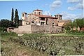
church building in Santpedor, Spain  | |||||
| Upload media | |||||
| Instance of | |||||
|---|---|---|---|---|---|
| Location | Claret, Santpedor, Bages, Barcelona Province, Catalonia | ||||
| Architectural style | |||||
| Heritage designation |
| ||||
 | |||||
Català: Santuari de Santa Anna de Claret a Santpedor (Bages)
This is a category about a building listed in the Catalan heritage register as Bé Cultural d'Interès Local (BCIL) under the reference IPA-17206. |
Subcategories
This category has only the following subcategory.
Media in category "Santa Anna de Claret"
This category contains only the following file.
-
 Santa Anna.jpg 2,816 × 1,880; 2.98 MB