Category:Sant Ponç de Molers
Jump to navigation
Jump to search
| Object location | | View all coordinates using: OpenStreetMap |
|---|
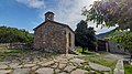
church building in Saldes, Spain  | |||||
| Upload media | |||||
| Instance of | |||||
|---|---|---|---|---|---|
| Location | Saldes, Berguedà, Catalunya Central, Catalonia | ||||
| Street address |
| ||||
| Architectural style | |||||
| Heritage designation |
| ||||
| Inception |
| ||||
| Elevation above sea level |
| ||||
 | |||||
Català: Sant Ponç de Molers, a Saldes, el Berguedà
This is a category about a building listed in the Catalan heritage register as Bé Cultural d'Interès Local (BCIL) under the reference IPA-3590. |
Media in category "Sant Ponç de Molers"
The following 8 files are in this category, out of 8 total.
-
 Sant Ponç de Molers - Absis.jpg 3,264 × 1,836; 2.43 MB
-
 Sant Ponç de Molers - Cartell informatiu.jpg 1,976 × 1,704; 1.7 MB
-
 Sant Ponç de Molers 1.jpg 4,000 × 2,250; 2.66 MB
-
 Sant Ponç de Molers 2.jpg 3,264 × 1,836; 1.67 MB
-
 Sant Ponç de Molers 3.jpg 3,264 × 1,836; 1.82 MB
-
 Sant Ponç de Molers 4.jpg 3,264 × 1,836; 1.72 MB
-
 Sant Ponç de Molers 5.jpg 4,000 × 2,250; 2.83 MB
-
 Sant Ponç de Molers 6.jpg 4,000 × 2,250; 3.6 MB


