Category:Sant Llorenç de Ratera
Jump to navigation
Jump to search
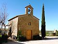
Català: Capella de Sant Llorenç (els Plans de Sió)
This is a category about a building listed in the Catalan heritage register as Bé Cultural d'Interès Local (BCIL) under the reference IPA-26135. |
| Object location | | View all coordinates using: OpenStreetMap |
|---|
 | |||||
| Upload media | |||||
| Instance of | |||||
|---|---|---|---|---|---|
| Location | Ratera, Els Plans de Sió, Segarra, Ponent, Province of Lleida, Catalonia | ||||
| Street address |
| ||||
| Architectural style | |||||
| Heritage designation |
| ||||
| Inception |
| ||||
| Elevation above sea level |
| ||||
 | |||||
Media in category "Sant Llorenç de Ratera"
The following 6 files are in this category, out of 6 total.
-
 Ermita ratera.jpg 700 × 525; 75 KB
-
 SANT LLORENÇ DE RATERA - IB-240.JPG 2,048 × 1,536; 764 KB
-
 SANT LLORENÇ DE RATERA - IB-241.JPG 1,536 × 2,048; 953 KB
-
 SANT LLORENÇ DE RATERA - IB-242.JPG 2,048 × 1,536; 1,007 KB
-
 SANT LLORENÇ DE RATERA - IB-244.JPG 2,048 × 1,536; 828 KB
-
 SANT LLORENÇ DE RATERA - IB-245.JPG 2,048 × 1,536; 1,008 KB


