Category:Sant Gil de Torà
Jump to navigation
Jump to search
| Object location | | View all coordinates using: OpenStreetMap |
|---|
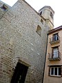
church building in Torà, Spain  | |||||
| Upload media | |||||
| Instance of | |||||
|---|---|---|---|---|---|
| Location | Torà, Solsonès, Lleida Province, Catalonia | ||||
| Street address |
| ||||
| Architectural style | |||||
| Heritage designation |
| ||||
| Inception |
| ||||
| Elevation above sea level |
| ||||
 | |||||
Català: Esglèsia parroquial de Sant Gil de Torà (Segarra)
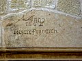
This is a category about a building listed in the Catalan heritage register as Bé Cultural d'Interès Local (BCIL) under the reference IPA-26300. |
Subcategories
This category has only the following subcategory.
Media in category "Sant Gil de Torà"
The following 48 files are in this category, out of 48 total.
-
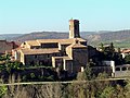
 040 Església de Sant Gil (Torà), des del cementiri.jpg 2,816 × 2,112; 2.59 MB
-
 044 Església de Sant Gil (Torà), des del cementiri.jpg 2,816 × 2,112; 2.51 MB
-
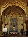
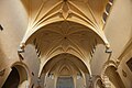
 051 Església de Sant Gil (Torà), nau.jpg 2,112 × 2,816; 1.65 MB
-
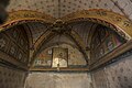
 052 Església de Sant Gil (Torà), sostre de volta de l'antiga capella dels Cardona.jpg 2,816 × 2,112; 1.71 MB
-
 053 Església de Sant Gil (Torà), capella del Sant Crist.jpg 2,112 × 2,816; 1.59 MB
-
 054 Església de Sant Gil (Torà), cúpula de la capella del Roser.jpg 2,816 × 2,112; 1.39 MB
-
 055 Església de Sant Gil (Torà), capelles del costat de llevant.jpg 2,816 × 2,112; 1.62 MB
-
 056 Església de Sant Gil (Torà), cúpula de la capella del Roser.jpg 2,816 × 2,112; 1.25 MB
-
 057 Església de Sant Gil (Torà), cúpula de la capella del Roser.jpg 2,816 × 2,112; 1.58 MB
-
 058 Església de Sant Gil (Torà), presbiteri i altar major.jpg 2,112 × 2,816; 1.65 MB
-
 059 Església de Sant Gil (Torà), pany del portal sud.jpg 2,816 × 2,112; 3.49 MB
-
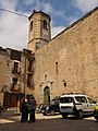
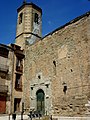
 062 Església de Sant Gil (Torà), façana sud i campanar.jpg 2,112 × 2,816; 2.94 MB
-
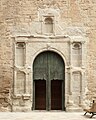
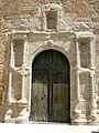
 063 Església de Sant Gil (Torà), portal sud.jpg 2,816 × 2,112; 2.66 MB
-
 065 Església de Sant Gil (Torà), portal sud i campanar.jpg 2,112 × 2,816; 2.18 MB
-

-
 PM 047748 E Tora.jpg 481 × 600; 292 KB
-
 PM 047749 E Tora.jpg 407 × 600; 214 KB
-
 PM 078907 E Tora.jpg 600 × 400; 212 KB
-
 PM 106369 E Tora.jpg 600 × 450; 187 KB
-
 PM 106372 E Tora.jpg 600 × 450; 221 KB
-
 PM 108805 E Tora.jpg 600 × 446; 247 KB
-
 PM 108806 E Tora.jpg 600 × 400; 221 KB
-
 PM 108807 E Tora.jpg 600 × 400; 166 KB
-
 PM 108808 E Tora.jpg 600 × 400; 149 KB
-
 PM 108811 E Tora.jpg 600 × 445; 198 KB
-
 PM 108814 E Tora.jpg 600 × 400; 217 KB
-
 PM 108815 E Tora.jpg 378 × 600; 247 KB
-
 PM 108816 E Tora.jpg 400 × 600; 237 KB
-
 PM 108817 E Tora.jpg 319 × 600; 245 KB
-
 PM 108819 E Tora.jpg 400 × 600; 180 KB
-
 PM 108820 E Tora.jpg 393 × 600; 179 KB
-
 PM 108821 E Tora.jpg 600 × 400; 170 KB
-
 PM 108822 E Tora.jpg 600 × 400; 164 KB
-
 PM 108823 E Tora.jpg 400 × 600; 161 KB
-
 PM 108824 E Tora.jpg 600 × 400; 240 KB
-
 SANT GIL - TORÀ - 2.JPG 1,536 × 2,048; 1.59 MB
-
 SANT GIL - TORÀ - IB-786.JPG 2,048 × 1,536; 1.64 MB
-
 SANT GIL - TORÀ - IB-787.JPG 1,536 × 2,048; 1.61 MB
-
 SANT GIL - TORÀ.JPG 1,280 × 960; 504 KB
-
 SANT GIL DE TORA - IB1.JPG 1,536 × 2,048; 1.5 MB
-
 SANT GIL DE TORA - IB2.JPG 1,536 × 2,048; 1.62 MB
-
 SANT GIL DE TORA - IB3.JPG 1,536 × 2,048; 1.49 MB
-
 SANT GIL DE TORA - IB4.JPG 1,536 × 2,048; 1.44 MB
-
 SANT GIL DE TORA - IB5.JPG 2,048 × 1,536; 1.71 MB
-
 SANT GIL DE TORA - IB6.JPG 1,536 × 2,048; 1.53 MB
-
 SANT GIL DE TORA - IB7.JPG 1,536 × 2,048; 1.15 MB
-
 SANT GIL DE TORA - IB8.JPG 2,048 × 1,536; 1.27 MB
-
 SANT GIL DE TORÀ - IB-P1000645.jpg 2,048 × 1,536; 1.76 MB
,_des_del_cementiri.jpg)
,_des_del_cementiri.jpg)
,_nau.jpg)
,_sostre_de_volta_de_l%27antiga_capella_dels_Cardona.jpg)
,_capella_del_Sant_Crist.jpg)
,_c%C3%BApula_de_la_capella_del_Roser.jpg)
,_capelles_del_costat_de_llevant.jpg)
,_c%C3%BApula_de_la_capella_del_Roser.jpg)
,_c%C3%BApula_de_la_capella_del_Roser.jpg)
,_presbiteri_i_altar_major.jpg)
,_pany_del_portal_sud.jpg)
,_fa%C3%A7ana_sud_i_campanar.jpg)
,_portal_sud.jpg)
,_portal_sud_i_campanar.jpg)


