Category:Sant Cebrià de Mollet de Peralada
Jump to navigation
Jump to search
| Object location | | View all coordinates using: OpenStreetMap |
|---|
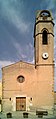
church building in Mollet de Peralada, Spain  | |||||
| Upload media | |||||
| Instance of | |||||
|---|---|---|---|---|---|
| Location | Mollet de Peralada, Alt Empordà, Comarques Gironines, Catalonia | ||||
| Diocese | |||||
| Heritage designation |
| ||||
| Religion or worldview | |||||
 | |||||
Català: Església parroquial de Sant Cebrià de Mollet (Mollet de Peralada)
This is a category about a building listed in the Catalan heritage register as Bé Cultural d'Interès Local (BCIL) under the reference IPA-17673. |
Media in category "Sant Cebrià de Mollet de Peralada"
The following 7 files are in this category, out of 7 total.
-
 Mollet de Peralada 2013 07 17 04 M8.jpg 2,030 × 4,311; 3.26 MB
-
 Mollet de Peralada 2013 07 17 05 M8.jpg 2,036 × 3,030; 2.47 MB
-
 Mollet de Peralada 2013 07 17 06 M8.jpg 3,030 × 2,036; 4.55 MB
-
 Mollet de Peralada 2013 07 17 08 M8.jpg 2,984 × 1,967; 3.35 MB
-
 Mollet de Peralada 2013 07 17 09 M8.jpg 3,030 × 2,036; 3.45 MB
-
 Mollet de Peralada 2013 07 17 11 IR M8.jpg 3,030 × 2,036; 3.57 MB
-
 Vinyes a Mollet de Perelada (Alt Empordà, Catalunya).jpg 2,448 × 3,264; 2.4 MB


.jpg)