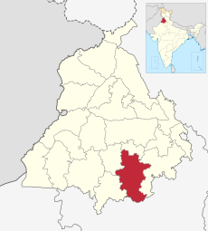
Category:Sangrur district
Jump to navigation
Jump to search
district in Punjab, India | |||||
| Upload media | |||||
| Instance of | |||||
|---|---|---|---|---|---|
| Location |
| ||||
| Capital | |||||
| Population |
| ||||
| Area |
| ||||
| Elevation above sea level |
| ||||
| official website | |||||
 | |||||
Sangrur district (Doabi:ਸਂਗਰੂਰ ਡਿਸਟ੍ਰਿਕਟ) is a unit part of the Republic of India, it is divided into 9 talukas.
Subcategories
This category has the following 7 subcategories, out of 7 total.
Media in category "Sangrur district"
The following 17 files are in this category, out of 17 total.
-
Bhutal kalan.jpg 4,032 × 3,024; 2.39 MB
-
Fld1 - panoramio.jpg 1,280 × 960; 483 KB
-
Glimpses of Bhutal kalan.jpg 1,600 × 900; 433 KB
-
Ground Lovers.jpg 4,144 × 1,968; 2.77 MB
-
Monsoon night of sunam (sangrur).jpg 1,242 × 2,208; 116 KB
-
Radhika Kumari With Her Medal.jpg 3,547 × 2,571; 1.25 MB
-
Smoke from Incense Sticks 01.jpg 2,736 × 1,824; 2.12 MB
-
Smoke from Incense Sticks 2.jpg 5,456 × 3,632; 8.7 MB
-
Smoke from Incense sticks.jpg 2,736 × 1,824; 1.98 MB
-
Unknown flower at Smoke from Incense sticks.jpg 5,456 × 3,632; 9.51 MB
-
Village Bhutal kalan.jpg 1,600 × 900; 508 KB
-
Warm Welcome Of Radhika Kumari.jpg 4,160 × 3,120; 1.24 MB
-
Way to town - panoramio.jpg 1,280 × 960; 430 KB
-
Wheat planting, near Sangrur, India (9192).jpg 1,280 × 848; 90 KB
-
ਗੁਰਦੁਆਰਾ ਗੁਰਪ੍ਰਕਾਸ ਖੇੜੀ ਸਾਹਿਬ.jpg 4,000 × 2,992; 3.74 MB
-
ਸਰਕਾਰੀ ਡਿਸਪੈਂਸਰੀ.jpg 4,000 × 2,992; 5.14 MB
-
ਸਰਕਾਰੀ ਹਾਈ ਸਕੂਲ ਖੇੜੀ.jpg 4,000 × 2,992; 2.33 MB


