Category:Sanborn maps of the Bronx published in 1909
Jump to navigation
Jump to search
Maps from: Insurance Maps of the City of New York Borough of the Bronx. Volume Ten. (New York: Sanborn Map Company, 1909). Comprising 90 maps (plates) in two parts: Part 1 (south, Plates No. 1–50) and Part 2 (north, Plates No. 51–90), plus volume keys for each part, title page (two copies), and street index (two copies).
Online at NYPL Digital Collection Beta website,
- Part 1: Atlas 49. Vol. 10, pt. 1, 1909
- Part 2: Atlas 49. Vol. 10, pt. 2, 1909
Media in category "Sanborn maps of the Bronx published in 1909"
The following 96 files are in this category, out of 96 total.
-

-
 Key NYPL1993360.tiff 5,397 × 7,187, 2 pages; 111.04 MB
-
 Index NYPL1993361.tiff 5,397 × 7,187, 2 pages; 111.04 MB
-
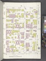
 Bronx, V. 10, Plate No. 1 (Map bounded by Summit Ave., Ogden Ave., Macombs Dam Bridge, Harlem River) NYPL1993362.tiff 5,397 × 7,187, 2 pages; 111.04 MB
-
 Bronx, V. 10, Plate No. 2 (Map bounded by W. 162nd St., Macomb's Dam Bridge, Exterior St., Ogden Ave.) NYPL1993363.tiff 5,397 × 7,187, 2 pages; 111.04 MB
-
 Bronx, V. 10, Plate No. 3 (Map bounded by Sedgwick Ave., E. 161st St., Cromwell Ave., E. 157th St.) NYPL1993364.tiff 5,397 × 7,187, 2 pages; 111.04 MB
-
 Bronx, V. 10, Plate No. 4 (Map bounded by E. 161st St., Gerard Ave., E. 157th St., Cromwell Ave.) NYPL1993365.tiff 5,397 × 7,187, 2 pages; 111.04 MB
-
 Bronx, V. 10, Plate No. 5 (Map bounded by Gerard Ave., E. 158th St., Sheridan Ave., E. 156th St.) NYPL1993366.tiff 5,397 × 7,187, 2 pages; 111.04 MB
-
 Bronx, V. 10, Plate No. 6 (Map bounded by Gerard Ave., E. 161st St., Sheridan Ave., E. 158th St.) NYPL1993367.tiff 5,397 × 7,187, 2 pages; 111.04 MB
-
 Bronx, V. 10, Plate No. 7 (Map bounded by Sheridan Ave., E. 158th St., E. 157th St., E. 156th St.) NYPL1993368.tiff 5,397 × 7,187, 2 pages; 111.04 MB
-
 Bronx, V. 10, Plate No. 8 (Map bounded by Sheridan Ave., E. 161st St., Park Ave., E. 158th St.) NYPL1993369.tiff 5,397 × 7,187, 2 pages; 111.04 MB
-

-
 Bronx, V. 10, Plate No. 10 (Map bounded by Park Ave., E. 161st St., Melrose Ave., E. 158th St.) NYPL1993371.tiff 5,397 × 7,187, 2 pages; 111.04 MB
-
 Bronx, V. 10, Plate No. 11 (Map bounded by E. 160th St., 3rd Ave., E. 156th St., Melrose Ave.) NYPL1993372.tiff 5,397 × 7,187, 2 pages; 111.04 MB
-
 Bronx, V. 10, Plate No. 12 (Map bounded by 3rd Ave., St. Ann's Ave., E. 156th St.) NYPL1993373.tiff 5,397 × 7,187, 2 pages; 111.04 MB
-
 Bronx, V. 10, Plate No. 13 (Map bounded by E. 161st St., Trinity Ave., E. 156th St., St. Ann's Ave.) NYPL1993374.tiff 5,397 × 7,187, 2 pages; 111.04 MB
-
 Bronx, V. 10, Plate No. 14 (Map bounded by E. 161st St., Tinton Ave., E. 156th St., Trinity Ave.) NYPL1993375.tiff 5,397 × 7,187, 2 pages; 111.04 MB
-
 Bronx, V. 10, Plate No. 15 (Map bounded by E. 161st St., Prospect Ave., E. 156th St., Tinton Ave.) NYPL1993376.tiff 5,397 × 7,187, 2 pages; 111.04 MB
-
 Bronx, V. 10, Plate No. 16 (Map bounded by Forest Ave., E. 163rd St., Prospect Ave., E. 161st St.) NYPL1993377.tiff 5,397 × 7,187, 2 pages; 111.04 MB
-
 Bronx, V. 10, Plate No. 17 (Map bounded by Harlem River, W. 164th St., Ogden Ave., W. 161st St.) NYPL1993378.tiff 5,397 × 7,187, 2 pages; 111.04 MB
-
 Bronx, V. 10, Plate No. 18 (Map bounded by W. 165th St., Ogden Ave., W. 162nd St., Lind Ave.) NYPL1993379.tiff 5,374 × 7,143, 2 pages; 109.89 MB
-
 Bronx, V. 10, Plate No. 19 (Map bounded by W. 165th St., Anderson Ave., W. 162nd St., Ogden Ave.) NYPL1993380.tiff 5,374 × 7,143, 2 pages; 109.89 MB
-
 Bronx, V. 10, Plate No. 20 (Map bounded by W. 165th St., Cromwell Ave., E. 162nd St., Anderson Ave.) NYPL1993381.tiff 5,374 × 7,143, 2 pages; 109.89 MB
-
 Bronx, V. 10, Plate No. 21 (Map bounded by Macomb's Dam Bridge, E. 162nd St., Gerard Ave., E. 161st St.) NYPL1993382.tiff 5,374 × 7,143, 2 pages; 109.89 MB
-
 Bronx, V. 10, Plate No. 22 (Map bounded by Jerome Ave., E. 164th St., Gerard Ave., E. 162nd St.) NYPL1993383.tiff 5,374 × 7,143, 2 pages; 109.89 MB
-
 Bronx, V. 10, Plate No. 23 (Map bounded by E. 164th St., Grand Blvd., E. 161st St., Gerard Ave.) NYPL1993384.tiff 5,374 × 7,143, 2 pages; 109.89 MB
-
 Bronx, V. 10, Plate No. 24 (Map bounded by Cromwell Ave., E. 165th St., Grand Blvd., E. 164th St.) NYPL1993385.tiff 5,374 × 7,143, 2 pages; 109.89 MB
-
 Bronx, V. 10, Plate No. 25 (Map bounded by Grand Blvd., E. 163rd St., Morris Ave., E. 161st St.) NYPL1993386.tiff 5,279 × 6,962, 2 pages; 105.21 MB
-
 Bronx, V. 10, Plate No. 26 (Map bounded by Morris Ave., E. 163rd St., Courtlandt Ave., E. 161st St.) NYPL1993387.tiff 5,374 × 7,143, 2 pages; 109.89 MB
-
 Bronx, V. 10, Plate No. 27 (Map bounded by E. 165th St., Sherman Ave., E. 163rd St., Grand Blvd.) NYPL1993388.tiff 5,374 × 7,143, 2 pages; 109.89 MB
-
 Bronx, V. 10, Plate No. 28 (Map bounded by E. 165th St., Morris Ave., E. 163rd St., Sherman Ave.) NYPL1993389.tiff 5,374 × 7,143, 2 pages; 109.89 MB
-
 Bronx, V. 10, Plate No. 29 (Map bounded by E. 165th St., Teller Ave., E. 163rd St., Morris Ave.) NYPL1993390.tiff 5,374 × 7,143, 2 pages; 109.89 MB
-
 Bronx, V. 10, Plate No. 30 (Map bounded by E. 165th St., Melrose Ave., E. 162nd St., Teller Ave.) NYPL1993391.tiff 5,374 × 7,143, 2 pages; 109.89 MB
-
 Bronx, V. 10, Plate No. 31 (Map bounded by E. 165th St., Washington Ave., E. 163rd St., Melrose Ave.) NYPL1993392.tiff 5,374 × 7,143, 2 pages; 109.89 MB
-
 Bronx, V. 10, Plate No. 32 (Map bounded by E. 165th St., Boston Rd., E. 163rd St., Washington Ave.) NYPL1993393.tiff 5,374 × 7,143, 2 pages; 109.89 MB
-
 Bronx, V. 10, Plate No. 33 (Map bounded by Courtlandt Ave., E. 163rd St., Washington Ave., E. 160th St.) NYPL1993394.tiff 5,374 × 7,143, 2 pages; 109.89 MB
-
 Bronx, V. 10, Plate No. 34 (Map bounded by Washington Ave., E. 163rd St., Eagle Ave., E. 161st St.) NYPL1993395.tiff 5,374 × 7,143, 2 pages; 109.89 MB
-
 Bronx, V. 10, Plate No. 35 (Map bounded by Eagle Ave., E. 163rd St., Forest Ave., E. 161st St.) NYPL1993396.tiff 5,374 × 7,143, 2 pages; 109.89 MB
-
 Bronx, V. 10, Plate No. 36 (Map bounded by 3rd Ave., E. 165th St., Forest Ave., E. 163rd St.) NYPL1993397.tiff 5,407 × 7,207, 2 pages; 111.55 MB
-
 Bronx, V. 10, Plate No. 37 (Map bounded by Forest Ave., E. 165th St., Prospect Ave., E. 163rd St.) NYPL1993398.tiff 5,407 × 7,207, 2 pages; 111.55 MB
-
 Bronx, V. 10, Plate No. 38 (Map bounded by Jackson Ave., E. 166th St., Prospect Ave., E. 165th St.) NYPL1993399.tiff 5,385 × 7,165, 2 pages; 110.45 MB
-
 Bronx, V. 10, Plate No. 39 (Map bounded by Harlem River, Sedgwick Ave., W. 164th St.) NYPL1993400.tiff 5,376 × 7,148, 2 pages; 110 MB
-
 Bronx, V. 10, Plate No. 40 (Map bounded by Union Pl., Ogden Ave., W. 165th St., Lind Ave., Lawrence Ave.) NYPL1993401.tiff 5,394 × 7,182, 2 pages; 110.9 MB
-
 Bronx, V. 10, Plate No. 41 (Map bounded by W. 167th St., Anderson Ave., W. 165th St., Ogden Ave.) NYPL1993402.tiff 5,368 × 7,132, 2 pages; 109.59 MB
-
 Bronx, V. 10, Plate No. 42 (Map bounded by W. 167th St., Cromwell Ave., E. 165th St., Anderson Ave.) NYPL1993403.tiff 5,368 × 7,132, 2 pages; 109.59 MB
-
 Bronx, V. 10, Plate No. 43 (Map bounded by McClellan St., Gerard Ave., E. 165th St., Cromwell Ave.) NYPL1993404.tiff 5,368 × 7,132, 2 pages; 109.59 MB
-
 Bronx, V. 10, Plate No. 44 (Map bounded by McClellan St., Grand Blvd., E. 165th St., Gerard Ave.) NYPL1993405.tiff 5,368 × 7,132, 2 pages; 109.59 MB
-
 Bronx, V. 10, Plate No. 45 (Map bounded by McClellan St., Sherman Ave., E. 165th St., Grand Blvd.) NYPL1993406.tiff 5,368 × 7,132, 2 pages; 109.59 MB
-
 Bronx, V. 10, Plate No. 46 (Map bounded by Sherman Ave., E. 166th St., Findlay Ave., E. 165th St.) NYPL1993407.tiff 5,387 × 7,168, 2 pages; 110.54 MB
-
 Bronx, V. 10, Plate No. 47 (Map bounded by E. 167th St., Webster Ave., E. 165th St., Findlay Ave.) NYPL1993408.tiff 5,364 × 7,124, 2 pages; 109.39 MB
-
 Bronx, V. 10, Plate No. 48 (Map bounded by E. 167th St., Washington Ave., E. 165th St., Brook Ave.) NYPL1993409.tiff 5,218 × 6,845, 2 pages; 102.25 MB
-
 Bronx, V. 10, Plate No. 49 (Map bounded by E. 167th St., Franklin Ave., E. 165th St., Washington Ave.) NYPL1993410.tiff 5,305 × 7,012, 2 pages; 106.49 MB
-
 Bronx, V. 10, Plate No. 50 (Map bounded by 3rd Ave., E. 166th St., Jackson Ave., E. 165th St.) NYPL1993411.tiff 5,258 × 6,922, 2 pages; 104.19 MB
-

-
 Index NYPL1996056.tiff 5,367 × 7,157, 2 pages; 109.96 MB
-
 Key NYPL1996057.tiff 5,357 × 7,142, 2 pages; 109.52 MB
-
 Bronx, V. 10, Plate No. 51 (Map bounded by Harlem River, W. 167th St., Lawrence Ave.) NYPL1996058.tiff 5,408 × 7,210, 2 pages; 111.62 MB
-
 Bronx, V. 10, Plate No. 52 (Map bounded by W. 167th St., Lind Ave.) NYPL1996059.tiff 5,357 × 7,142, 2 pages; 109.52 MB
-
 Bronx, V. 10, Plate No. 53 (Map bounded by Lind Ave., W. 168th St., Woodycrest Ave., W. 167th St., Union PL.) NYPL1996060.tiff 5,408 × 7,210, 2 pages; 111.62 MB
-
 Bronx, V. 10, Plate No. 54 (Map bounded by W. 169th St., Cromwell Ave., Jerome Ave., W. 167th St., Woodycrest Ave.) NYPL1996061.tiff 5,357 × 7,142, 2 pages; 109.52 MB
-
 Bronx, V. 10, Plate No. 55 (Map bounded by E. 168th St., Gerard Ave., McClellan St., Jerome Ave.) NYPL1996062.tiff 5,380 × 7,173, 2 pages; 110.47 MB
-
 Bronx, V. 10, Plate No. 56 (Map bounded by E. 168th St., Grand Blvd., McClellan St., Greand Ave.) NYPL1996063.tiff 5,377 × 7,170, 2 pages; 110.36 MB
-
 Bronx, V. 10, Plate No. 57 (Map bounded by Grand Blvd., E. 167th St., McClellan St.) NYPL1996064.tiff 5,388 × 7,185, 2 pages; 110.82 MB
-
 Bronx, V. 10, Plate No. 58 (Map bounded by E. 167th St., Findlay Ave., E. 166th St., Grant Ave.) NYPL1996065.tiff 5,377 × 7,170, 2 pages; 110.36 MB
-
 Bronx, V. 10, Plate No. 59 (Map bounded by Morris Ave., W. 168th St., Clay Ave., E. 167th St.) NYPL1996066.tiff 5,408 × 7,210, 2 pages; 111.62 MB
-
 Bronx, V. 10, Plate No. 60 (Map bounded by Morris Ave., E. 169th St., Clay Ave., E. 168th St.) NYPL1996067.tiff 5,405 × 7,207, 2 pages; 111.51 MB
-
 Bronx, V. 10, Plate No. 61 (Map bounded by Clay Ave., E. 168th St., Washington Ave., E. 167th St.) NYPL1996068.tiff 5,392 × 7,190, 2 pages; 110.98 MB
-
 Bronx, V. 10, Plate No. 62 (Map bounded by Clay Ave., E. 169th St., Washington Ave., E. 168th St.) NYPL1996069.tiff 5,405 × 7,207, 2 pages; 111.51 MB
-
 Bronx, V. 10, Plate No. 63 (Map bounded by E. 169th St., Fulton Ave., E. 167th St., Washington Ave.) NYPL1996070.tiff 5,392 × 7,190, 2 pages; 110.98 MB
-
 Bronx, V. 10, Plate No. 64 (Map bounded by E. 168th St., Jackson Ave., E. 166th St., Fulton Ave.) NYPL1996071.tiff 5,373 × 7,164, 2 pages; 110.19 MB
-
 Bronx, V. 10, Plate No. 65 (Map bounded by E. 168th St., Tinton Ave., E. 166th St., Jackson Ave.) NYPL1996072.tiff 5,392 × 7,190, 2 pages; 110.98 MB
-
 Bronx, V. 10, Plate No. 66 (Map bounded by E. 168th St., Prospect Ave., E. 166th St., Tinton Ave.) NYPL1996073.tiff 5,350 × 7,134, 2 pages; 109.26 MB
-
 Bronx, V. 10, Plate No. 67 (Map bounded by Fulton Ave., 169th St., Tinton Ave., E. 168th St.) NYPL1996074.tiff 5,392 × 7,190, 2 pages; 110.98 MB
-
 Bronx, V. 10, Plate No. 68 (Map bounded by Jennings St., Prospect Ave., E. 168th St., Tinton Ave.) NYPL1996075.tiff 5,397 × 7,195, 2 pages; 111.16 MB
-
 Bronx, V. 10, Plate No. 69 (Map bounded by Harlem River, Commerce Ave., W. 169th St., W. 167th St.) NYPL1996076.tiff 5,409 × 7,212, 2 pages; 111.67 MB
-
 Bronx, V. 10, Plate No. 70 (Map bounded by W. 170th St., Ogden Ave., W. 168th St., W. 167th St.) NYPL1996077.tiff 5,397 × 7,195, 2 pages; 111.16 MB
-
 Bronx, V. 10, Plate No. 71 (Map bounded by Harlem River, Washington Bridge, Sedgwick Ave.) NYPL1996078.tiff 5,409 × 7,212, 2 pages; 111.67 MB
-
 Bronx, V. 10, Plate No. 72 (Map bounded by Washington Bridge, Merriam Ave., W. 170th St., Sedgwick Ave.) NYPL1996079.tiff 5,397 × 7,195, 2 pages; 111.16 MB
-
 Bronx, V. 10, Plate No. 73 (Map bounded by Merriam Ave., Boscobel Ave., Nelson Ave., W. 170th St.) NYPL1996080.tiff 5,402 × 7,202, 2 pages; 111.37 MB
-
 Bronx, V. 10, Plate No. 74 (Map bounded by W. 170th St., Shakespeare Ave., W. 168th St., Ogden Ave.) NYPL1996081.tiff 5,397 × 7,195, 2 pages; 111.16 MB
-
 Bronx, V. 10, Plate No. 75 (Map bounded by Nelson Ave., Inwood Ave., W. 169th St.) NYPL1996082.tiff 5,402 × 7,202, 2 pages; 111.37 MB
-
 Bronx, V. 10, Plate No. 76 (Map bounded by W. 170th St., Jerome Ave., W. 169th St., Boscobel Ave.) NYPL1996083.tiff 5,397 × 7,195, 2 pages; 111.16 MB
-
 Bronx, V. 10, Plate No. 77 (Map bounded by Jerome Ave., Clarke Place, Grand Blvd., E. 168th St.) NYPL1996084.tiff 5,402 × 7,203, 2 pages; 111.39 MB
-
 Bronx, V. 10, Plate No. 78 (Map bounded by Jerome Ave., E. 170th St., Grand Blvd., Clarke Place) NYPL1996085.tiff 5,354 × 7,138, 2 pages; 109.4 MB
-
 Bronx, V. 10, Plate No. 79 (Map bounded by E. 170th St., Grant Ave., E. 169th St., Grand Blvd.) NYPL1996086.tiff 5,401 × 7,201, 2 pages; 111.33 MB
-
 Bronx, V. 10, Plate No. 80 (Map bounded by Grand Blvd., E. 169th St., Morris Ave., E. 167th St.) NYPL1996087.tiff 5,398 × 7,198, 2 pages; 111.23 MB
-
 Bronx, V. 10, Plate No. 81 (Map bounded by E. 170th St., Findlay Ave., E. 169th St., Grant Ave.) NYPL1996088.tiff 5,408 × 7,211, 2 pages; 111.63 MB
-
 Bronx, V. 10, Plate No. 82 (Map bounded by E. 170th St., Webster Ave., E. 169th St., Findlay Ave.) NYPL1996089.tiff 5,398 × 7,198, 2 pages; 111.23 MB
-
 Bronx, V. 10, Plate No. 83 (Map bounded by St. Paul's Place, Washington Ave., E. 169th St., Webster Ave.) NYPL1996090.tiff 5,408 × 7,211, 2 pages; 111.63 MB
-
 Bronx, V. 10, Plate No. 84 (Map bounded by Wendover Ave., Park Ave., St. Paul's Place, Clay Ave.) NYPL1996091.tiff 5,384 × 7,179, 2 pages; 110.64 MB
-
 Bronx, V. 10, Plate No. 85 (Map bounded by Park Ave., E. 171st St., Fulton Ave., St. Paul's Place) NYPL1996092.tiff 5,408 × 7,211, 2 pages; 111.63 MB
-
 Bronx, V. 10, Plate No. 86 (Map bounded by Park Ave., Wendover Ave., Fulton Ave., E. 171st St.) NYPL1996093.tiff 5,327 × 7,103, 2 pages; 108.32 MB
-
 Bronx, V. 10, Plate No. 87 (Map bounded by St. Paul's Place, Fulton Ave., E. 169th St., Washington Ave.) NYPL1996094.tiff 5,385 × 7,180, 2 pages; 110.68 MB
-
 Bronx, V. 10, Plate No. 88 (Map bounded by E. 170th St., Clinton Ave., E. 169th St., Fulton Ave.) NYPL1996095.tiff 5,358 × 7,144, 2 pages; 109.57 MB
-
 Bronx, V. 10, Plate No. 89 (Map bounded by E. 170th St., Prospect Ave., E. 169th St., Clinton Ave.) NYPL1996096.tiff 5,385 × 7,180, 2 pages; 110.68 MB
-
