Category:Sanborn maps of the Bronx published in 1908, V. 9
Jump to navigation
Jump to search
Maps from: Insurance Maps of the City of New York Borough of the Bronx. Volume Nine. (New York: Sanborn Map Company, 1908). Comprising title page (absent from NYPL), volume key (missing from this category), and street index, plus 86 maps (plates) of which this category is missing No. 24.
Online at The New YorkPublic Library Digital Collections website, Atlas 45. Vol. 9, 1908.
Media in category "Sanborn maps of the Bronx published in 1908, V. 9"
The following 86 files are in this category, out of 86 total.
-
 Index NYPL1990799.tiff 5,368 × 7,132, 2 pages; 109.59 MB
-
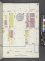
 Bronx, V. 9, Plate No. 1 (Map bounded by Harlem River, E. 135th St., 3rd Ave.) NYPL1990801.tiff 5,409 × 7,210, 2 pages; 111.64 MB
-
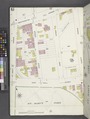
 Bronx, V. 9, Plate No. 2 (Map bounded by Mott Ave., E. 138th St., Lincoln Ave., E. 135th St.) NYPL1990802.tiff 5,404 × 7,202, 2 pages; 111.41 MB
-
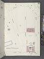
 Bronx, V. 9, Plate No. 3 (Map bounded by 3rd Ave., Lincoln Ave., Harlem River) NYPL1990803.tiff 5,409 × 7,210, 2 pages; 111.64 MB
-
 Bronx, V. 9, Plate No. 4 (Map bounded by E. 134th St., Alexander Ave., Harlem River, Lincoln Ave.) NYPL1990804.tiff 5,404 × 7,202, 2 pages; 111.41 MB
-
 Bronx, V. 9, Plate No. 5 (Map bounded by E. 132nd St., Harlem River) NYPL1990805.tiff 5,409 × 7,210, 2 pages; 111.64 MB
-
 Bronx, V. 9, Plate No. 6 (Map bounded by E. 132nd St., Bronx Kills, Harlem River) NYPL1990806.tiff 5,404 × 7,202, 2 pages; 111.41 MB
-
 Bronx, V. 9, Plate No. 7 (Map bounded by E. 132nd St., Bronx Kills) NYPL1990807.tiff 5,409 × 7,210, 2 pages; 111.64 MB
-
 Bronx, V. 9, Plate No. 8 (Map bounded by E. 134th St., St. Ann's Ave., Bronx Kills, Brook Ave.) NYPL1990808.tiff 5,404 × 7,202, 2 pages; 111.41 MB
-
 Bronx, V. 9, Plate No. 9 (Map bounded by Bronx Kills) NYPL1990809.tiff 5,409 × 7,210, 2 pages; 111.64 MB
-
 Bronx, V. 9, Plate No. 10 (Map bounded by St. Ann's Ave., E. 134th St., Cypress Ave., E. 132nd St.) NYPL1990810.tiff 5,404 × 7,202, 2 pages; 111.41 MB
-
 Bronx, V. 9, Plate No. 11 (Map bounded by Bronx Kills) NYPL1990811.tiff 5,409 × 7,210, 2 pages; 111.64 MB
-
 Bronx, V. 9, Plate No. 12 (Map bounded by Cypress Ave., E. 134th St., Willow Ave., E. 132nd St.) NYPL1990812.tiff 5,404 × 7,202, 2 pages; 111.41 MB
-
 Bronx, V. 9, Plate No. 13 (Map bounded by East River) NYPL1990813.tiff 5,409 × 7,210, 2 pages; 111.64 MB
-
 Bronx, V. 9, Plate No. 14 (Map bounded by E. 132nd St., East River) NYPL1990814.tiff 5,404 × 7,202, 2 pages; 111.41 MB
-
 Bronx, V. 9, Plate No. 15 (Map bounded by E. 132nd St., Walnut Ave., E. 135th St., East River) NYPL1990815.tiff 5,409 × 7,210, 2 pages; 111.64 MB
-
 Bronx, V. 9, Plate No. 16 (Map bounded by Walnut Ave., E. 138th St., East River, E. 135th St.) NYPL1990816.tiff 5,404 × 7,202, 2 pages; 111.41 MB
-
 Bronx, V. 9, Plate No. 17 (Map bounded by Willow Ave., E. 135th St., Walnut Ave., E. 132nd St.) NYPL1990817.tiff 5,409 × 7,210, 2 pages; 111.64 MB
-
 Bronx, V. 9, Plate No. 18 (Map bounded by Willow Ave., E. 138th St., Walnut Ave., E. 135th St.) NYPL1990818.tiff 5,404 × 7,202, 2 pages; 111.41 MB
-
 Bronx, V. 9, Plate No. 19 (Map bounded by E. 138th St., Southern Blvd., E. 141st St., Walnut Ave.) NYPL1990819.tiff 5,409 × 7,210, 2 pages; 111.64 MB
-
 Bronx, V. 9, Plate No. 20 (Map bounded by Walnut Ave., E. 141st St., East River, E. 138th St.) NYPL1990820.tiff 5,404 × 7,202, 2 pages; 111.41 MB
-
 Bronx, V. 9, Plate No. 21 (Map bounded by E. 134th St., Cypress Ave., E. 137th St., Willow Ave.) NYPL1990821.tiff 5,409 × 7,210, 2 pages; 111.64 MB
-
 Bronx, V. 9, Plate No. 22 (Map bounded by E. 137th St., Cypress Ave., E. 140th St., Willow Ave.) NYPL1990822.tiff 5,388 × 7,169, 2 pages; 110.57 MB
-
 Bronx, V. 9, Plate No. 23 (Map bounded by E. 134th St., St. Ann's Ave., E. 137th St., Cypress Ave.) NYPL1990823.tiff 5,388 × 7,169, 2 pages; 110.57 MB
-
 Bronx, V. 9, Plate No. 25 (Map bounded by Brook Ave., E. 138th St., St. Ann's Ave., E. 134th St.) NYPL1990825.tiff 5,388 × 7,169, 2 pages; 110.57 MB
-
 Bronx, V. 9, Plate No. 26 (Map bounded by E. 142nd St., St. Ann's Ave., E. 138th St., Brook Ave.) NYPL1990826.tiff 5,405 × 7,202, 2 pages; 111.43 MB
-
 Bronx, V. 9, Plate No. 27 (Map bounded by E. 132nd St., Willis Ave., E. 135th St., Brook Ave.) NYPL1990827.tiff 5,388 × 7,169, 2 pages; 110.57 MB
-
 Bronx, V. 9, Plate No. 28 (Map bounded by Willis Ave., E. 138th St., Brook Ave., E. 135th St.) NYPL1990828.tiff 5,405 × 7,202, 2 pages; 111.43 MB
-
 Bronx, V. 9, Plate No. 29 (Map bounded by E. 138th St., Alexander Ave., E. 134th St., Lincoln Ave.) NYPL1990829.tiff 5,405 × 7,202, 2 pages; 111.43 MB
-
 Bronx, V. 9, Plate No. 30 (Map bounded by E. 136th St., Willis Ave., E. 132nd St., Alexander Ave.) NYPL1990830.tiff 5,405 × 7,202, 2 pages; 111.43 MB
-
 Bronx, V. 9, Plate No. 31 (Map bounded by Morris Ave., E. 141st St., Alexander Ave., E. 138th St.) NYPL1990831.tiff 5,388 × 7,169, 2 pages; 110.57 MB
-
 Bronx, V. 9, Plate No. 32 (Map bounded by E. 140th St., Willis Ave., E. 136th St., Alexander Ave.) NYPL1990832.tiff 5,369 × 7,133, 2 pages; 109.63 MB
-
 Bronx, V. 9, Plate No. 33 (Map bounded by E. 138thSt., Willis Ave., E. 141st St., Brook Ave.) NYPL1990833.tiff 5,388 × 7,169, 2 pages; 110.57 MB
-
 Bronx, V. 9, Plate No. 34 (Map bounded by Willis Ave., E. 144th St., Brook Ave., E. 141st St.) NYPL1990834.tiff 5,353 × 7,103, 2 pages; 108.84 MB
-
 Bronx, V. 9, Plate No. 35 (Map bounded by Morris Ave., E. 146th St., 3rd Ave., E. 141st St.) NYPL1990835.tiff 5,388 × 7,169, 2 pages; 110.57 MB
-
 Bronx, V. 9, Plate No. 36 (Map bounded by 3rd Ave., E. 144th St., Willis Ave., E. 140th St., Alexander Ave.) NYPL1990836.tiff 5,353 × 7,103, 2 pages; 108.84 MB
-
 Bronx, V. 9, Plate No. 37 (Map bounded by Park Ave., E. 141st St., Morris Ave., E. 138th St.) NYPL1990837.tiff 5,388 × 7,169, 2 pages; 110.57 MB
-
 Bronx, V. 9, Plate No. 38 (Map bounded by E. 148th St., Morris Ave., E. 141st St., Park Ave.) NYPL1990838.tiff 5,353 × 7,103, 2 pages; 108.84 MB
-
 Bronx, V. 9, Plate No. 39 (Map bounded by Harlem River, E. 138th St., Mott Ave., Park Ave.) NYPL1990839.tiff 5,388 × 7,169, 2 pages; 110.57 MB
-
 Bronx, V. 9, Plate No. 40 (Map bounded by Harlem River, Cheever Pl., Park Ave., E. 138th St.) NYPL1990840.tiff 5,320 × 7,039, 2 pages; 107.2 MB
-
 Bronx, V. 9, Plate No. 41 (Map bounded by Harlem River) NYPL1990841.tiff 5,388 × 7,169, 2 pages; 110.57 MB
-
 Bronx, V. 9, Plate No. 42 (Map bounded by Exterior St., E. 144th St., Park Ave., Cheever Pl.) NYPL1990842.tiff 5,305 × 7,011, 2 pages; 106.47 MB
-
 Bronx, V. 9, Plate No. 43 (Map bounded by Exterior St., E. 150th St., Walton Ave., E. 144th St.) NYPL1990843.tiff 5,388 × 7,169, 2 pages; 110.57 MB
-
 Bronx, V. 9, Plate No. 44 (Map bounded by E. 150th St., Park Ave., E. 144th St., Walton Ave.) NYPL1990844.tiff 5,345 × 7,088, 2 pages; 108.45 MB
-
 Bronx, V. 9, Plate No. 45 (Map bounded by Park Ave., E. 152nd St., Morris Ave., E. 148th St.) NYPL1990845.tiff 5,388 × 7,169, 2 pages; 110.57 MB
-
 Bronx, V. 9, Plate No. 46 (Map bounded by Morris Ave., E. 150th St., Courtlandt Ave., E. 146th St.) NYPL1990846.tiff 5,317 × 7,035, 2 pages; 107.08 MB
-
 Bronx, V. 9, Plate No. 47 (Map bounded by E. 148th St., Willis Ave., E. 144th St., College Ave.) NYPL1990847.tiff 5,388 × 7,169, 2 pages; 110.57 MB
-
 Bronx, V. 9, Plate No. 48 (Map bounded by Willis Ave., E. 147th St., Brook Ave., E. 144th St.) NYPL1990848.tiff 5,319 × 7,037, 2 pages; 107.15 MB
-
 Bronx, V. 9, Plate No. 49 (Map bounded by Brook Ave., E. 147th St., St. Ann's Ave., E. 142nd St.) NYPL1990849.tiff 5,361 × 7,118, 2 pages; 109.24 MB
-
 Bronx, V. 9, Plate No. 50 (Map bounded by St. Ann's Ave., St. Mary's St.) NYPL1990850.tiff 5,317 × 7,035, 2 pages; 107.08 MB
-
 Bronx, V. 9, Plate No. 51 (Map bounded by St. Ann's Ave., St. Mary's St., Cypress Ave., E. 140th St.) NYPL1990851.tiff 5,361 × 7,118, 2 pages; 109.24 MB
-
 Bronx, V. 9, Plate No. 52 (Map bounded by St. Mary's St., Robbins Ave., E. 140th St., Beekman Ave.) NYPL1990852.tiff 5,317 × 7,035, 2 pages; 107.08 MB
-
 Bronx, V. 9, Plate No. 53 (Map bounded by E. 140th St., Robbins Ave., E. 142nd St., Southern Blvd.) NYPL1990853.tiff 5,361 × 7,118, 2 pages; 109.24 MB
-
 Bronx, V. 9, Plate No. 54 (Map bounded by E. 145th St., Southern Blvd., E. 142nd St., Robbins Ave.) NYPL1990854.tiff 5,317 × 7,035, 2 pages; 107.08 MB
-
 Bronx, V. 9, Plate No. 55 (Map bounded by E. 141st St., Whitlock Ave.) NYPL1990855.tiff 5,361 × 7,118, 2 pages; 109.24 MB
-
 Bronx, V. 9, Plate No. 56 (Map bounded by E. 149th St., East River, E. 141st St.) NYPL1990856.tiff 5,317 × 7,035, 2 pages; 107.08 MB
-
 Bronx, V. 9, Plate No. 57 (Map bounded by Southern Blvd., E. 145th St., Whitlock Ave.) NYPL1990857.tiff 5,361 × 7,118, 2 pages; 109.24 MB
-
 Bronx, V. 9, Plate No. 58 (Map bounded by E. 149th St., Whitlock Ave.) NYPL1990858.tiff 5,317 × 7,035, 2 pages; 107.08 MB
-
 Bronx, V. 9, Plate No. 59 (Map bounded by Wales Ave., E. 149th St., Timpson Pl.,, E. 145th St.) NYPL1990859.tiff 5,361 × 7,118, 2 pages; 109.24 MB
-
 Bronx, V. 9, Plate No. 60 (Map bounded by Southern Blvd., E. 149th St., Whitlock Ave., 144th St., Timpson Pl.) NYPL1990860.tiff 5,317 × 7,035, 2 pages; 107.08 MB
-
 Bronx, V. 9, Plate No. 61 (Map bounded by St. Ann's Ave., Westchester Ave., Trinity Ave., E. 149th St.) NYPL1990861.tiff 5,361 × 7,118, 2 pages; 109.24 MB
-
 Bronx, V. 9, Plate No. 62 (Map bounded by E. 149th St., Wales Ave., E. 145th St., Trinity Ave.) NYPL1990862.tiff 5,317 × 7,035, 2 pages; 107.08 MB
-
 Bronx, V. 9, Plate No. 63 (Map bounded by Trinity Ave., E. 132nd St., Wales Ave., E. 149th St.) NYPL1990863.tiff 5,361 × 7,118, 2 pages; 109.24 MB
-
 Bronx, V. 9, Plate No. 64 (Map bounded by E. 152nd St., Prospect Ave., E. 149th St., Wales Ave.) NYPL1990864.tiff 5,317 × 7,035, 2 pages; 107.08 MB
-
 Bronx, V. 9, Plate No. 65 (Map bounded by Jackson Ave., E. 156th St., Tinton Ave., E. 152nd St.) NYPL1990865.tiff 5,361 × 7,118, 2 pages; 109.24 MB
-
 Bronx, V. 9, Plate No. 66 (Map bounded by E. 156th St., Prospect Ave., E. 152nd St., Tinton Ave.) NYPL1990866.tiff 5,317 × 7,035, 2 pages; 107.08 MB
-
 Bronx, V. 9, Plate No. 67 (Map bounded by German Pl., E. 156th St., Eagle Ave., Westchester Ave.) NYPL1990867.tiff 5,361 × 7,118, 2 pages; 109.24 MB
-
 Bronx, V. 9, Plate No. 68 (Map bounded by E. 156th St., Jackson Ave., Westchester Ave., Eagle Ave.) NYPL1990868.tiff 5,317 × 7,035, 2 pages; 107.08 MB
-
 Bronx, V. 9, Plate No. 69 (Map bounded by Westchester Ave., Brook Ave., E. 147th St., 3rd Ave.) NYPL1990869.tiff 5,361 × 7,118, 2 pages; 109.24 MB
-
 Bronx, V. 9, Plate No. 70 (Map bounded by Westchester Ave., St. Ann's Ave., E. 147th St., Brook Ave.) NYPL1990870.tiff 5,340 × 7,077, 2 pages; 108.18 MB
-
 Bronx, V. 9, Plate No. 71 (Map bounded by Courtlandt Ave., E. 150th St., Bergen Ave.) NYPL1990871.tiff 5,361 × 7,118, 2 pages; 109.24 MB
-
 Bronx, V. 9, Plate No. 72 (Map bounded by Courtlandt Ave., E. 153rd St., Bergen Ave., E. 150th St.) NYPL1990872.tiff 5,340 × 7,077, 2 pages; 108.18 MB
-
 Bronx, V. 9, Plate No. 73 (Map bounded by Courtlandt Ave., E. 156th St., 3rd Ave., E. 153rd St.) NYPL1990873.tiff 5,361 × 7,118, 2 pages; 109.24 MB
-
 Bronx, V. 9, Plate No. 74 (Map bounded by E. 156th St., German Pl., E. 152nd St., 3rd Ave.) NYPL1990874.tiff 5,387 × 7,167, 2 pages; 110.52 MB
-
 Bronx, V. 9, Plate No. 75 (Map bounded by E. 150th St., Morris Ave., E. 153rd St., Courtlandt Ave.) NYPL1990875.tiff 5,361 × 7,118, 2 pages; 109.24 MB
-
 Bronx, V. 9, Plate No. 76 (Map bounded by Morris Ave., E. 156th St., Courtlandt Ave., E. 153rd St.) NYPL1990876.tiff 5,387 × 7,167, 2 pages; 110.52 MB
-
 Bronx, V. 9, Plate No. 77 (Map bounded by Walton Ave., Sheridan Ave., E. 153rd St.) NYPL1990877.tiff 5,361 × 7,118, 2 pages; 109.24 MB
-
 Bronx, V. 9, Plate No. 78 (Map bounded by E. 156th St., Morris Ave., E. 152nd St., Sheridan Ave.) NYPL1990878.tiff 5,354 × 7,104, 2 pages; 108.88 MB
-
 Bronx, V. 9, Plate No. 79 (Map bounded by River Ave., E. 153rd St., E. 150th St.) NYPL1990879.tiff 5,361 × 7,118, 2 pages; 109.24 MB
-
 Bronx, V. 9, Plate No. 80 (Map bounded by Walton Ave., E. 150th St.) NYPL1990880.tiff 5,354 × 7,104, 2 pages; 108.88 MB
-
 Bronx, V. 9, Plate No. 81 (Map bounded by Harlem River, River Ave., E. 146th St.) NYPL1990881.tiff 5,361 × 7,118, 2 pages; 109.24 MB
-
 Bronx, V. 9, Plate No. 82 (Map bounded by Ferncliff Pl., E. 151st St., River Ave., E. 150th St., Exterior St.) NYPL1990882.tiff 5,376 × 7,146, 2 pages; 109.97 MB
-
 Bronx, V. 9, Plate No. 83 (Map bounded by Exterior St., E. 157th St., Cromwell Ave., Ferncliff Pl.) NYPL1990883.tiff 5,361 × 7,118, 2 pages; 109.24 MB
-
 Bronx, V. 9, Plate No. 84 (Map bounded by E. 157th St., Walton Ave., Cromwell Ave.) NYPL1990884.tiff 5,349 × 7,096, 2 pages; 108.66 MB
-
 Bronx, V. 9, Plate No. 85 (Map bounded by Harlem River, Exterior St.) NYPL1990885.tiff 5,349 × 7,096, 2 pages; 108.66 MB
-
 Bronx, V. 9, Plate No. 86 (Map bounded by Harlem River, E. 158th St., Exterior St.) NYPL1990886.tiff 5,361 × 7,118, 2 pages; 109.24 MB