Category:Sanborn maps of the Bronx published in 1901
Jump to navigation
Jump to search
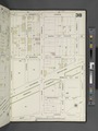
Maps from: Insurance Maps of The City of New York. Volume 14. (New York: Sanborn–Perris Map Co., Limited; 1901), comprising 62 maps (plates) plus title page, street index, and two-page volume key.
Online at The New York Public Library Digital Collections website, Atlas 52. Vol. 14, 1901.
Plate 34 (image ID 2003323) is missing from this category.
Media in category "Sanborn maps of the Bronx published in 1901"
The following 65 files are in this category, out of 65 total.
-

-
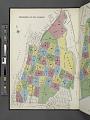 Key NYPL2003288.tiff 6,726 × 8,976, 2 pages; 172.79 MB
-
 Key continued NYPL2003289.tiff 6,665 × 8,895, 2 pages; 169.68 MB
-
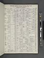 Index NYPL2003286.tiff 6,732 × 8,984, 2 pages; 173.1 MB
-
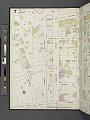
 Bronx, V. 14, Plate No. 1 (Map bounded by Relmont St., Morris Ave., Teller Ave., E. 170th St., Grand Blvd.) NYPL2003290.tiff 6,726 × 8,976, 2 pages; 172.79 MB
-
 Bronx, V. 14, Plate No. 2 (Map bounded by Grand Blvd., Weeks Ave., Belmont St.) NYPL2003291.tiff 6,673 × 8,905, 2 pages; 170.07 MB
-
 Bronx, V. 14, Plate No. 3 (Map bounded by E. 175th St., Anthony Ave., Belmont St., Weeks Ave.) NYPL2003292.tiff 6,726 × 8,976, 2 pages; 172.79 MB
-
 Bronx, V. 14, Plate No. 4 (Map bounded by E. 178th St., Anthony Ave., E. 175th St., Grand Blvd.) NYPL2003293.tiff 6,673 × 8,905, 2 pages; 170.07 MB
-
 Bronx, V. 14, Plate No. 5 (Map bounded by E. 174th St., Washington Ave., Wendover Ave., Clay Ave.) NYPL2003294.tiff 6,726 × 8,976, 2 pages; 172.79 MB
-
 Bronx, V. 14, Plate No. 6 (Map bounded by E. 174th St., Fulton Ave., Wendover Ave., Washington Ave.) NYPL2003295.tiff 6,673 × 8,905, 2 pages; 170.07 MB
-
 Bronx, V. 14, Plate No. 7 (Map bounded by Tremont Ave., Park Ave., E. 174th Ave., Anthony Ave.) NYPL2003296.tiff 6,726 × 8,976, 2 pages; 172.79 MB
-
 Bronx, V. 14, Plate No. 8 (Map bounded by Tremont Ave., 3rd Ave., E. 174th St., Park Ave.) NYPL2003297.tiff 6,673 × 8,905, 2 pages; 170.07 MB
-
 Bronx, V. 14, Plate No. 9 (Map bounded by E. 177th St., Arthur Ave., 3rd Ave.) NYPL2003298.tiff 6,726 × 8,976, 2 pages; 172.79 MB
-
 Bronx, V. 14, Plate No. 10 (Map bounded by E. 177th St., Prospect Ave., Crotona Park North, Belmont Ave.) NYPL2003299.tiff 6,691 × 8,929, 2 pages; 170.99 MB
-
 Bronx, V. 14, Plate No. 11 (Map bounded by E. 181st St., Belmont Ave., E. 177th St., Lafontaine Ave.) NYPL2003300.tiff 6,726 × 8,976, 2 pages; 172.79 MB
-
 Bronx, V. 14, Plate No. 12 (Map bounded by E. 181st St., Prospect Ave., E. 177th St., Belmont Ave.) NYPL2003301.tiff 6,692 × 8,931, 2 pages; 171.05 MB
-
 Bronx, V. 14, Plate No. 13 (Map bounded by Park Ave., E. 179th St., Lafontaine Ave., E. 177th St.) NYPL2003302.tiff 6,726 × 8,976, 2 pages; 172.79 MB
-
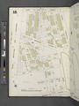
 Bronx, V. 14, Plate No. 14 (Map bounded by Park Ave., E. 181st St., Lafontaine Ave., E. 179th St.) NYPL2003303.tiff 6,690 × 8,928, 2 pages; 170.95 MB
-
 Bronx, V. 14, Plate No. 15 (Map bounded by E. 180th St., Ryer Ave., Tremont Ave., Grand Blvd.) NYPL2003304.tiff 6,728 × 8,978, 2 pages; 172.88 MB
-
 Bronx, V. 14, Plate No. 16 (Map bounded by E. 180th St., Park Ave., Tremont Ave., Ryer Ave.) NYPL2003305.tiff 6,687 × 8,925, 2 pages; 170.81 MB
-
 Bronx, V. 14, Plate No. 17 (Map bounded by E. 183rd St., Tiebout Ave., E. 180th St., Grand Blvd.) NYPL2003306.tiff 6,728 × 8,978, 2 pages; 172.88 MB
-
 Bronx, V. 14, Plate No. 18 (Map bounded by E. 189th St., Tiebout Ave., E. 183rd St., Grand Blvd.) NYPL2003307.tiff 6,690 × 8,928, 2 pages; 170.95 MB
-
 Bronx, V. 14, Plate No. 19 (Map bounded by Ford St., Park Ave., E. 180th St., Valentine Ave.) NYPL2003308.tiff 6,728 × 8,978, 2 pages; 172.88 MB
-
 Bronx, V. 14, Plate No. 20 (Map bounded by E. 189th St., Park Ave., E. 183rd St., Tiebout Ave.) NYPL2003309.tiff 6,673 × 8,905, 2 pages; 170.07 MB
-
 Bronx, V. 14, Plate No. 21 (Map bounded by E. 184th St., Bathgate Ave., E. 181st St., Park Ave.) NYPL2003310.tiff 6,728 × 8,978, 2 pages; 172.88 MB
-
 Bronx, V. 14, Plate No. 22 (Map bounded by E. 184th St., Arthur Ave., E. 181st St., Bathgate Ave.) NYPL2003311.tiff 6,682 × 8,917, 2 pages; 170.53 MB
-
 Bronx, V. 14, Plate No. 23 (Map bounded by Arthur Ave., E. 183rd St., Clinton Ave., E. 181st St.) NYPL2003312.tiff 6,728 × 8,979, 2 pages; 172.9 MB
-
 Bronx, V. 14, Plate No. 24 (Map bounded by Hoffman St., E. 187th St., Beaumont Ave.) NYPL2003313.tiff 6,690 × 8,929, 2 pages; 170.96 MB
-
 Bronx, V. 14, Plate No. 25 (Map bounded by Park Ave., E. 188th St., Hoffman St., E. 184th St.) NYPL2003314.tiff 6,711 × 8,955, 2 pages; 172 MB
-
 Bronx, V. 14, Plate No. 26 (Map bounded by Park Ave., E. 191st St., Hoffman St., E. 188th St.) NYPL2003315.tiff 6,700 × 8,942, 2 pages; 171.47 MB
-
 Bronx, V. 14, Plate No. 27 (Map bounded by E. 191st St., Cambreleng Ave., E. 187th St., Hoffman St.) NYPL2003316.tiff 6,711 × 8,955, 2 pages; 172 MB
-
 Bronx, V. 14, Plate No. 28 (Map bounded by Pelham Ave., Southern Blvd., E. 187th St., Cambreleng Ave.) NYPL2003317.tiff 6,693 × 8,932, 2 pages; 171.1 MB
-
 Bronx, V. 14, Plate No. 29 (Map bounded by Webster Ave., Southern Blvd., Pelham Ave.) NYPL2003318.tiff 6,700 × 8,941, 2 pages; 171.45 MB
-
 Bronx, V. 14, Plate No. 30 (Map bounded by Bronx River, Southern Blvd., Mosholu Parkway) NYPL2003319.tiff 6,690 × 8,928, 2 pages; 170.95 MB
-
 Bronx, V. 14, Plate No. 31 (Map bounded by E. 182nd St., Southern Blvd., E. 179th St., Clinton Ave.) NYPL2003320.tiff 6,700 × 8,941, 2 pages; 171.45 MB
-
 Bronx, V. 14, Plate No. 32 (Map bounded by E. 187th St., Southern Blvd., E. 182nd St., Beaumont Ave.) NYPL2003321.tiff 6,673 × 8,905, 2 pages; 170.07 MB
-
 Bronx, V. 14, Plate No. 33 (Map bounded by E. 182nd St., Daly Ave., E. 178th St., Southern Blvd.) NYPL2003322.tiff 6,727 × 8,978, 2 pages; 172.85 MB
-
 Bronx, V. 14, Plate No. 35 (Map bounded by E. 179th St., Bryant St., E. 176th St., Southern Blvd.) NYPL2003324.tiff 6,723 × 8,972, 2 pages; 172.63 MB
-
 Bronx, V. 14, Plate No. 36 (Map bounded by E. 179th St., Bronx River, E. 176th St., Bryant St.) NYPL2003325.tiff 6,673 × 8,905, 2 pages; 170.07 MB
-
 Bronx, V. 14, Plate No. 37 (Map bounded by Prospect Ave., Fairmount Place, Crotona Parkway, Crotona Parkway East) NYPL2003326.tiff 6,724 × 8,974, 2 pages; 172.7 MB
-
 Bronx, V. 14, Plate No. 38 (Map bounded by Prospect Ave., E. 179th St., Daly Ave., Fairmount Place.) NYPL2003327.tiff 6,673 × 8,905, 2 pages; 170.07 MB
-
 Bronx, V. 14, Plate No. 39 (Map bounded by E. 176th St., Bryant St., E. 173rd St., Crotona Park East.) NYPL2003328.tiff 6,698 × 8,938, 2 pages; 171.34 MB
-
 Bronx, V. 14, Plate No. 40 (Map bounded by E. 176th St., Bronx River, E. 173rd St., Bryant St.) NYPL2003329.tiff 6,673 × 8,905, 2 pages; 170.07 MB
-

-
 Bronx, V. 14, Plate No. 42 (Map bounded by Crotona Park East, Minford Place, Wendover Ave.) NYPL2003331.tiff 6,673 × 8,905, 2 pages; 170.07 MB
-
 Bronx, V. 14, Plate No. 43 (Map bounded by Intervale Ave., Jennings St., Boone St., Home St.) NYPL2003332.tiff 6,698 × 8,938, 2 pages; 171.34 MB
-
 Bronx, V. 14, Plate No. 44 (Map bounded by Minford Place, E. 173rd St., Boone St.) NYPL2003333.tiff 6,673 × 8,905, 2 pages; 170.07 MB
-
 Bronx, V. 14, Plate No. 45 (Map bounded by Home St., Bronx River, Aldus St., Faile St.) NYPL2003334.tiff 6,698 × 8,938, 2 pages; 171.34 MB
-
 Bronx, V. 14, Plate No. 46 (Map bounded by E. 172nd St., Bronx River, Home St., Boone St.) NYPL2003335.tiff 6,673 × 8,905, 2 pages; 170.07 MB
-
 Bronx, V. 14, Plate No. 47 (Map bounded by Freeman St., Barretto St., E. 167th St., Prospect Ave.) NYPL2003336.tiff 6,707 × 8,951, 2 pages; 171.82 MB
-
 Bronx, V. 14, Plate No. 48 (Map bounded by Freeman St., Vyse St., E. 167th St., Barretto St.) NYPL2003337.tiff 6,692 × 8,930, 2 pages; 171.03 MB
-
 Bronx, V. 14, Plate No. 49 (Map bounded by Prospect Ave., E. 165th St., Barretto St., Dongan St.) NYPL2003338.tiff 6,707 × 8,951, 2 pages; 171.82 MB
-
 Bronx, V. 14, Plate No. 50 (Map bounded by Prospect Ave., E. 167th St., Barretto St., E. 165th St.) NYPL2003339.tiff 6,699 × 8,940, 2 pages; 171.4 MB
-
 Bronx, V. 14, Plate No. 51 (Map bounded by Aldus St., Bronx River., Lafayette Ave., Hunt's Point Rd.) NYPL2003340.tiff 6,716 × 8,962, 2 pages; 172.26 MB
-
 Bronx, V. 14, Plate No. 52 (Map bounded by E. 167th St., Faile St., Aldus St., Barretto St.) NYPL2003341.tiff 6,682 × 8,917, 2 pages; 170.53 MB
-
 Bronx, V. 14, Plate No. 53 (Map bounded by Southern Blvd., Tiffany St., E. 156th St.) NYPL2003342.tiff 6,725 × 8,974, 2 pages; 172.72 MB
-
 Bronx, V. 14, Plate No. 54 (Map bounded by Southern Blvd., Hunt's Point Rd., Spofford Ave., Tiffany St.) NYPL2003343.tiff 6,673 × 8,905, 2 pages; 170.07 MB
-
 Bronx, V. 14, Plate No. 55 (Map bounded by E. 163rd St., Dawson St., E. 156th St., Prospect Ave.) NYPL2003344.tiff 6,725 × 8,974, 2 pages; 172.72 MB
-
 Bronx, V. 14, Plate No. 56 (Map bounded by Dongan St., Southern Blvd., Longwood Ave., Dawson St.) NYPL2003345.tiff 6,673 × 8,905, 2 pages; 170.07 MB
-
 Bronx, V. 14, Plate No. 57 (Map bounded by Prospect Ave., Leggett Ave., Timpson Place) NYPL2003346.tiff 6,725 × 8,974, 2 pages; 172.72 MB
-
 Bronx, V. 14, Plate No. 58 (Map bounded by Leggett Ave., Dawson St., Longwood Ave., Whitlock Ave.) NYPL2003347.tiff 6,673 × 8,905, 2 pages; 170.07 MB
-
 Bronx, V. 14, Plate No. 59 (Map bounded by Coster St., East River, E. 149th St., Southern Blvd.) NYPL2003348.tiff 6,725 × 8,974, 2 pages; 172.72 MB
-
 Bronx, V. 14, Plate No. 60 (Map bounded by Lafayette Ave., Bronx River, East River, Coster St.) NYPL2003349.tiff 6,673 × 8,905, 2 pages; 170.07 MB
-
 Bronx, V. 14, Plate No. 61 (Map bounded by 175th St., Crotona Park East, Crotona Park South, Fulton Ave.) NYPL2003350.tiff 6,717 × 8,964, 2 pages; 172.33 MB
-
 Bronx, V. 14, Plate No. 62 (Map bounded by Pelham Ave., Bronx River, E. 182nd St., Southern Blvd.) NYPL2003351.tiff 6,673 × 8,905, 2 pages; 170.07 MB