Category:Sanborn maps of the Bronx published in 1898
Jump to navigation
Jump to search
Maps from: Insurance maps of the City of New York (Borough of the Bronx) Surveyed and Published by Sanborn–Perris Map Co., Limited. Volume A. (New York: 1898), comprising 68 maps (plates) plus title page, street index, and volume key. Plates 41, 43, 44, and 45 are missing from this category.
Online at The New York Public Library Digital Collections website, Atlas 43. Vol. A, 1898.
Media in category "Sanborn maps of the Bronx published in 1898"
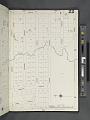
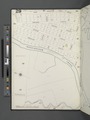
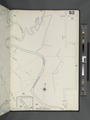
The following 67 files are in this category, out of 67 total.
-

-
 Index NYPL2003513.tiff 6,724 × 8,974, 2 pages; 172.7 MB
-
 Key NYPL2003514.tiff 6,692 × 8,931, 2 pages; 171.05 MB
-
 Bronx, V. A, Plate No. 1 (Map bounded by Fordham Ave., Bear Swamp Rd., Bronx River) NYPL2003516.tiff 6,723 × 8,971, 2 pages; 172.62 MB
-
 Bronx, V. A, Plate No. 2 (Map bounded by Bear Swamp Rd., Fordham Ave.) NYPL2003517.tiff 6,702 × 8,944, 2 pages; 171.56 MB
-
 Bronx, V. A, Plate No. 3 (Map bounded by Bear Swamp Rd., Bronx Park) NYPL2003518.tiff 6,723 × 8,971, 2 pages; 172.62 MB
-
 Bronx, V. A, Plate No. 4 (Map bounded by Morris Park Ave., Bronxdale and Unionport Rd.) NYPL2003519.tiff 6,702 × 8,944, 2 pages; 171.56 MB
-
 Bronx, V. A, Plate No. 5 (Map bounded by Fordham Ave., Williamsbridge Rd., Bear Swamp Rd.) NYPL2003520.tiff 6,639 × 8,859, 2 pages; 168.33 MB
-
 Bronx, V. A, Plate No. 6 (Map bounded by Williamsbridge Rd., Bear Swamp Rd.) NYPL2003521.tiff 6,690 × 8,927, 2 pages; 170.93 MB
-
 Bronx, V. A, Plate No. 7 (Map bounded by Morris Park Ave., West Farms Rd., Unionport Rd.) NYPL2003522.tiff 6,673 × 8,905, 2 pages; 170.07 MB
-
 Bronx, V. A, Plate No. 8 (Map bounded by Morris Park Ave., Bear Swamp Rd., W. Farms Rd., Madison St.) NYPL2003523.tiff 6,690 × 8,927, 2 pages; 170.93 MB
-
 Bronx, V. A, Plate No. 9 (Map bounded by Morris Park Ave., W. Farms Rd.) NYPL2003524.tiff 6,702 × 8,943, 2 pages; 171.54 MB
-
 Bronx, V. A, Plate No. 10 (Map bounded by Morris Park Ave., Unionport Rd., W. Farms Rd., Hancock St.) NYPL2003525.tiff 6,690 × 8,927, 2 pages; 170.93 MB
-
 Bronx, V. A, Plate No. 11 (Map bounded by Morris Park Ave., Bronx Park) NYPL2003526.tiff 6,702 × 8,943, 2 pages; 171.54 MB
-
 Bronx, V. A, Plate No. 12 (Map bounded by Watson's Lane, Bronx River, W. Farms Rd.) NYPL2003527.tiff 6,690 × 8,927, 2 pages; 170.93 MB
-
 Bronx, V. A, Plate No. 13 (Map bounded by Bronx River, Westchester Turnpike) NYPL2003528.tiff 6,702 × 8,943, 2 pages; 171.54 MB
-
 Bronx, V. A, Plate No. 14 (Map bounded by Westchester Turnpike) NYPL2003529.tiff 6,690 × 8,927, 2 pages; 170.93 MB
-
 Bronx, V. A, Plate No. 15 (Map bounded by W. Farms Rd., Clausons Point Rd., Beacon St., Rosedale Ave.) NYPL2003530.tiff 6,702 × 8,943, 2 pages; 171.54 MB
-
 Bronx, V. A, Plate No. 16 (Map bounded by W. Farms Rd., Cornell Ave., Clauson's Point Rd.) NYPL2003531.tiff 6,690 × 8,927, 2 pages; 170.93 MB
-
 Bronx, V. A, Plate No. 17 (Map bounded by W. Farms Rd., Old Rd.) NYPL2003532.tiff 6,711 × 8,955, 2 pages; 172 MB
-
 Bronx, V. A, Plate No. 18 (Map bounded by Bear Swamp Rd., Green Lane, Glebe Ave.) NYPL2003533.tiff 6,681 × 8,916, 2 pages; 170.49 MB
-
 Bronx, V. A, Plate No. 19 (Map bounded by Virginia Ave., Beacon St., Cornell Ave.) NYPL2003534.tiff 6,711 × 8,955, 2 pages; 172 MB
-
 Bronx, V. A, Plate No. 20 (Map bounded by Avenue D, 13th St., Virginia Ave., Old Rd.) NYPL2003535.tiff 6,690 × 8,927, 2 pages; 170.93 MB
-
 Bronx, V. A, Plate No. 21 (Map bounded by Avenue D, 8th St., Virginia Ave., 13th St.) NYPL2003536.tiff 6,711 × 8,955, 2 pages; 172 MB
-
 Bronx, V. A, Plate No. 22 (Map bounded by Avenue D, 3rd St., Cobb Ave., 8th St.) NYPL2003537.tiff 6,690 × 8,927, 2 pages; 170.93 MB
-
 Bronx, V. A, Plate No. 23 (Map bounded by Avenue B, 6th St., Avenue D, 11th St.) NYPL2003538.tiff 6,715 × 8,961, 2 pages; 172.22 MB
-
 Bronx, V. A, Plate No. 24 (Map bounded by Avenue B, 1st St., Avenue D, 6th St.) NYPL2003539.tiff 6,690 × 8,927, 2 pages; 170.93 MB
-
 Bronx, V. A, Plate No. 25 (Map bounded by Avenue B, 11th St., Avenue D, Westchester Turnpike) NYPL2003540.tiff 6,715 × 8,961, 2 pages; 172.22 MB
-
 Bronx, V. A, Plate No. 26 (Map bounded by Westchester Creek, 10th St., Avenue B, 15th St.) NYPL2003541.tiff 6,690 × 8,927, 2 pages; 170.93 MB
-
 Bronx, V. A, Plate No. 27 (Map bounded by Westchester Creek, 6th St., Avenue B, 10th St.) NYPL2003542.tiff 6,715 × 8,961, 2 pages; 172.22 MB
-
 Bronx, V. A, Plate No. 28 (Map bounded by Eastern Blvd., 1st St., Avenue B, 6th St.) NYPL2003543.tiff 6,712 × 8,957, 2 pages; 172.06 MB
-
 Bronx, V. A, Plate No. 29 (Map bounded by Fort Schuyler Rd., Seberry Creek) NYPL2003544.tiff 6,715 × 8,961, 2 pages; 172.22 MB
-
 Bronx, V. A, Plate No. 30 (Map bounded by Vreeland Ave., Balcom Ave., Eastern Blvd., Westchester Creek) NYPL2003545.tiff 6,704 × 8,947, 2 pages; 171.67 MB
-
 Bronx, V. A, Plate No. 31 (Map bounded by Parker Ave., Westchester Turnpike, Unionport Rd.) NYPL2003546.tiff 6,715 × 8,961, 2 pages; 172.22 MB
-
 Bronx, V. A, Plate No. 32 (Map bounded by Glebe Ave., Union Ave., 15th St., Grace Ave.) NYPL2003547.tiff 6,730 × 8,982, 2 pages; 173.01 MB
-
 Bronx, V. A, Plate No. 33 (Map bounded by Railroad Ave., Westchester Creek, Union Ave.) NYPL2003548.tiff 6,704 × 8,946, 2 pages; 171.65 MB
-
 Bronx, V. A, Plate No. 34 (Map bounded by Westchester Creek, Un-Named Rd., Main St., Franklin Ave.) NYPL2003549.tiff 6,709 × 8,953, 2 pages; 171.91 MB
-
 Bronx, V. A, Plate No. 35 (Map bounded by W. Farms Rd., Washington Ave., Railroad Ave., Green Lane) NYPL2003550.tiff 6,731 × 8,983, 2 pages; 173.05 MB
-
 Bronx, V. A, Plate No. 36 (Map bounded by Poplar St., Blondell Ave., Washington Ave.) NYPL2003551.tiff 6,723 × 8,972, 2 pages; 172.63 MB
-
 Bronx, V. A, Plate No. 37 (Map bounded by Bronx and Pelham Parkway, Eastchester Rd., Williamsbridge Rd.) NYPL2003552.tiff 6,723 × 8,972, 2 pages; 172.63 MB
-
 Bronx, V. A, Plate No. 38 (Map bounded by Williamsbridge Rd., Saratoga Ave., Westchester Creek, Main St.) NYPL2003553.tiff 6,723 × 8,972, 2 pages; 172.63 MB
-
 Bronx, V. A, Plate No. 39 (Map bounded by Elberon Ave., Bronx and Pelham Parkway, Pilgrim Ave., Liberty Alice St.) NYPL2003554.tiff 6,723 × 8,972, 2 pages; 172.63 MB
-
 Bronx, V. A, Plate No. 40 (Map bounded by Bronx and Pelham Parkway, Eastern Blvd., Liberty St., Pilgrim Ave.) NYPL2003555.tiff 6,723 × 8,972, 2 pages; 172.63 MB
-
 Bronx, V. A, Plate No. 42 (Map bounded by Pelham Rd., Eastern Blvd., Middletown Rd.) NYPL2003557.tiff 6,731 × 8,983, 2 pages; 173.05 MB
-
 Bronx, V. A, Plate No. 46 (Map bounded by 3rd St., Eastern Blvd., Fort Schuyler Rd.) NYPL2003561.tiff 6,703 × 8,945, 2 pages; 171.6 MB
-
 Bronx, V. A, Plate No. 47 (Map bounded by St. Joseph's Ave., Westchester Creek, Eastern Blvd.) NYPL2003562.tiff 6,724 × 8,973, 2 pages; 172.68 MB
-
 Bronx, V. A, Plate No. 48 (Map bounded by Throgg's Neck Rd., St. Joseph's Ave., Eastern Blvd.) NYPL2003563.tiff 6,703 × 8,945, 2 pages; 171.6 MB
-
 Bronx, V. A, Plate No. 49 (Map bounded by 2nd St., 1st St., Westchester St.) NYPL2003564.tiff 6,724 × 8,973, 2 pages; 172.68 MB
-
 Bronx, V. A, Plate No. 50 (Map bounded by Westchester Creek, Bancroft St.) NYPL2003565.tiff 6,703 × 8,945, 2 pages; 171.6 MB
-
 Bronx, V. A, Plate No. 51 (Map bounded by Pugsley Ave., East River) NYPL2003566.tiff 6,719 × 8,967, 2 pages; 172.44 MB
-
 Bronx, V. A, Plate No. 52 (Map bounded by 2nd St., Meadow Path) NYPL2003567.tiff 6,703 × 8,945, 2 pages; 171.6 MB
-
 Bronx, V. A, Plate No. 53 (Map bounded by Cobb Ave., Larkin Ave., Clauson's Point Rd., Westchester Turnpike) NYPL2003568.tiff 6,719 × 8,967, 2 pages; 172.44 MB
-
 Bronx, V. A, Plate No. 54 (Map bounded by E. 177th St., Clauson's Point Rd., Larkin Ave.) NYPL2003569.tiff 6,703 × 8,945, 2 pages; 171.6 MB
-
 Bronx, V. A, Plate No. 55 (Map bounded by Westchester Turnpike, Bronx River) NYPL2003570.tiff 6,693 × 8,931, 2 pages; 171.08 MB
-
 Bronx, V. A, Plate No. 56 (Map bounded by Westchester Turnpike, Clauson's Point Rd.) NYPL2003571.tiff 6,717 × 8,963, 2 pages; 172.31 MB
-
 Bronx, V. A, Plate No. 57 (Map bounded by Bronx River) NYPL2003572.tiff 6,693 × 8,931, 2 pages; 171.08 MB
-
 Bronx, V. A, Plate No. 58 (Map bounded by Westchester Creek, East River) NYPL2003573.tiff 6,717 × 8,963, 2 pages; 172.31 MB
-
 Bronx, V. A, Plate No. 59 (Map bounded by East River, Westchester Creek) NYPL2003574.tiff 6,693 × 8,931, 2 pages; 171.08 MB
-
 Bronx, V. A, Plate No. 60 (Map bounded by Throgg's Neck Rd., East River) NYPL2003575.tiff 6,731 × 8,983, 2 pages; 173.05 MB
-
 Bronx, V. A, Plate No. 61 (Map bounded by Fort Schuyler Rd., Long Island Sound, East River) NYPL2003576.tiff 6,673 × 8,905, 2 pages; 170.07 MB
-
 Bronx, V. A, Plate No. 62 (Map bounded by Throgg's Neck Rd., Weir Creek, Long Island Sound) NYPL2003577.tiff 6,731 × 8,983, 2 pages; 173.05 MB
-
 Bronx, V. A, Plate No. 63 (Map bounded by Throgg's Neck Rd., Long Island Sound, Weir Creek) NYPL2003578.tiff 6,673 × 8,905, 2 pages; 170.07 MB
-
 Bronx, V. A, Plate No. 64 (Map bounded by Throgg's Neck Rd., Town Dock Rd., Long Island Rd.) NYPL2003579.tiff 6,731 × 8,983, 2 pages; 173.05 MB
-
 Bronx, V. A, Plate No. 65 (Map bounded by Eastern Blvd., North Rd., Eastchester Bay, Town Dock Rd.) NYPL2003580.tiff 6,653 × 8,879, 2 pages; 169.07 MB
-
 Bronx, V. A, Plate No. 66 (Map bounded by Eastern Blvd., North Rd.) NYPL2003581.tiff 6,704 × 8,947, 2 pages; 171.67 MB
-
 Bronx, V. A, Plate No. 67 (Map bounded by Eastern Blvd., Eastchester Bay) NYPL2003582.tiff 6,628 × 8,846, 2 pages; 167.81 MB
-
 Bronx, V. A, Plate No. 68 (Map bounded by Eastern Blvd., Fordham Ave., Eastchester Bay) NYPL2003583.tiff 6,673 × 8,906, 2 pages; 170.09 MB