Category:Sanborn Fire Insurance Map from Wheatland, Platte County, Wyoming, 1918
Jump to navigation
Jump to search
See parent category for index.
Media in category "Sanborn Fire Insurance Map from Wheatland, Platte County, Wyoming, 1918"
The following 7 files are in this category, out of 7 total.
-
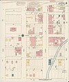
 Sanborn Fire Insurance Map from Wheatland, Platte County, Wyoming, 1918, Plate 0001.jpg 6,510 × 7,707; 4.03 MB
-
 Sanborn Fire Insurance Map from Wheatland, Platte County, Wyoming, 1918, Plate 0002.jpg 6,510 × 7,707; 3.27 MB
-
 Sanborn Fire Insurance Map from Wheatland, Platte County, Wyoming, 1918, Plate 0003.jpg 6,510 × 7,707; 3.97 MB
-
 Sanborn Fire Insurance Map from Wheatland, Platte County, Wyoming, 1918, Plate 0004.jpg 6,510 × 7,707; 3.07 MB
-
 Sanborn Fire Insurance Map from Wheatland, Platte County, Wyoming, 1918, Plate 0004.tiff 6,510 × 7,707; 143.55 MB
-
 Sanborn Fire Insurance Map from Wheatland, Platte County, Wyoming, 1918, Plate 0005.jpg 6,510 × 7,707; 3.3 MB
-
 Sanborn Fire Insurance Map from Wheatland, Platte County, Wyoming, 1918, Plate 0006.jpg 6,510 × 7,707; 3.42 MB


