Category:San Gabriel River (California)
Jump to navigation
Jump to search
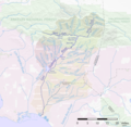
English: The San Gabriel River — of the San Gabriel Mountains, San Gabriel Valley, and Los Angeles Basin of of Southern California..
- The San Gabriel River flows 60.6 miles (97.5 km) through southeastern Los Angeles County, in California.
river in Los Angeles County, California, United States   | |||||
| Upload media | |||||
| Instance of | |||||
|---|---|---|---|---|---|
| Location |
| ||||
| Length |
| ||||
| Mouth of the watercourse | |||||
| Drainage basin |
| ||||
| Basin country | |||||
| Tributary |
| ||||
 | |||||
Subcategories
This category has the following 6 subcategories, out of 6 total.
Media in category "San Gabriel River (California)"
The following 52 files are in this category, out of 52 total.
-
 San Gabriel River Map.jpg 728 × 669; 279 KB
-
 Riverslosangeles.jpg 1,739 × 1,691; 3.46 MB
-
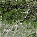 SanGabrielRiverCA ASTER 2005jan23.jpg 540 × 540; 132 KB
-
 East-Fort-San-Gabriel-River.jpg 4,000 × 3,000; 3.75 MB
-
 San-Gabriel-River-North-Fork.jpg 3,000 × 4,000; 3.16 MB
-
 West-Fork-San-Gabriel-River.jpg 4,000 × 3,000; 3.08 MB
-

-

-

-

-

-

-
 Alamitos Bay and San Gabriel River.jpg 3,358 × 1,576; 4.14 MB
-
 ANF East Fork01.jpg 2,560 × 1,920; 2.09 MB
-
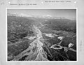 California - San Gabriel - NARA - 23935183.jpg 4,350 × 3,382; 2.56 MB
-
 California - San Gabriel - NARA - 23935185.jpg 4,350 × 3,382; 3.31 MB
-
 California - San Gabriel - NARA - 23935187.jpg 4,350 × 3,382; 3.21 MB
-

-

-
 Coyote Creek (San Gabriel River).jpg 4,416 × 3,064; 3.65 MB
-
-
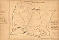
 Diseño Del Rancho Paso de Bartolo Viejo 1852-10-04.jpg 1,881 × 2,292; 1.33 MB
-
 East Fork of the San Gabriel River 01.jpg 6,000 × 4,000; 22.5 MB
-
 East Fork of the San Gabriel River 02.jpg 6,000 × 4,000; 19.72 MB
-
 East Fork of the San Gabriel River 03.jpg 4,000 × 6,000; 20.56 MB
-
 FEMA - 1311 - Photograph by Dave Gatley taken on 02-26-1998 in California.jpg 2,001 × 3,103; 5.04 MB
-
 Fire Road along crest east of Mt. Wilson - Flickr - pellaea.jpg 6,474 × 2,629; 4.69 MB
-
 Firestone Blvd at 605, Norwalk, San Gabriel River and Rio San Gabriel Park, Downey.jpg 1,022 × 1,423; 801 KB
-
 First water (327235848).jpg 1,600 × 1,233; 502 KB
-
 Floods - California - Bueena Park through Yoba Linda - NARA - 68157397.jpg 6,843 × 5,347; 18.38 MB
-
 Morris 21.jpg 3,456 × 2,304; 1.17 MB
-
 Morris-Dam.jpg 1,024 × 768; 153 KB
-
 Reservoir in the San Gabriel Mountains.jpg 1,920 × 2,560; 988 KB
-
 San Gabriel Dam upstream.jpg 4,288 × 3,216; 3.09 MB
-
 San Gabriel River at Heaton Flats.jpg 3,264 × 2,448; 6.45 MB
-
 San Gabriel River at Seal Beach California.jpg 2,592 × 1,944; 1.85 MB
-
 San Gabriel River CA.jpg 1,019 × 575; 136 KB
-
 San Gabriel river map.png 1,155 × 1,125; 894 KB
-
 San Gabriel River with 605 405 Junction.jpg 4,896 × 3,264; 10.06 MB
-
 San Gabriel River with Water in it.jpg 3,924 × 3,041; 6.58 MB
-
 San Gabriel River, CA (ASTER).jpg 3,028 × 2,632; 2.59 MB
-
 San-gabriel-biketrail-3200x1800.jpg 3,200 × 1,800; 1.21 MB
-
 San-gabriel-biketrail-800x450.jpg 800 × 450; 154 KB
-
 Sangabrielcanyon.jpg 2,400 × 1,800; 867 KB
-
 SanGabrielRiverSiteDedication.jpg 960 × 1,248; 271 KB
-
 Sangabrielwater.jpg 2,400 × 1,800; 1,006 KB
-
 Sgranf.jpg 2,400 × 1,800; 972 KB
-
 Coyotecreekocmap.png 1,131 × 820; 994 KB
-
 Watersheds of Los Angeles County, California.jpg 1,594 × 1,197; 672 KB
-
 West Fork of San Gabriel River - Flickr - pellaea (1).jpg 2,736 × 3,648; 3.44 MB
-
 West Fork of San Gabriel River - Flickr - pellaea.jpg 7,164 × 2,557; 3.37 MB
-
 Alnus rhombifolia San Gabriel River.jpg 2,448 × 3,264; 8.51 MB


_crop.jpg)
.jpg)
.jpg)


.jpg)


.jpg)


.jpg)
