Category:Saltmarshes in the East Riding of Yorkshire
Jump to navigation
Jump to search
Ceremonial counties of England: Cheshire · Cornwall · Cumbria · Devon · Dorset · East Riding of Yorkshire · East Sussex · Essex · Gloucestershire · Greater London · Hampshire · Kent · Lancashire · Lincolnshire · Merseyside · Norfolk · Northumberland · Somerset · Suffolk · West Sussex ·
City-counties:
Former historic counties:
Other former counties:
City-counties:
Former historic counties:
Other former counties:

Subcategories
This category has only the following subcategory.
T
Media in category "Saltmarshes in the East Riding of Yorkshire"
The following 43 files are in this category, out of 43 total.
-
 A Flat Tyre - geograph.org.uk - 1344184.jpg 479 × 640; 120 KB
-
 Boats at Easington Clough - geograph.org.uk - 290094.jpg 640 × 473; 101 KB
-
 Broomfleet Island - geograph.org.uk - 584769.jpg 640 × 479; 82 KB
-
 Broomfleet Island - geograph.org.uk - 584771.jpg 640 × 480; 100 KB
-
 Burstall Priory - geograph.org.uk - 322572.jpg 640 × 481; 113 KB
-
 Crabley Creek, Broomfleet Island - geograph.org.uk - 584776.jpg 640 × 453; 56 KB
-
 Creek on the Welwick Saltmarsh (geograph 5562379).jpg 800 × 625; 122 KB
-
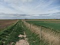
 Drain and flood bank at the Welwick Saltmarsh (geograph 5562364).jpg 800 × 541; 108 KB
-
 Easington Bank - geograph.org.uk - 305520.jpg 640 × 475; 109 KB
-
 Fence across the Welwick Saltmarsh (geograph 5562235).jpg 800 × 567; 115 KB
-

-
-
 Foulholme Sands - geograph.org.uk - 306357.jpg 640 × 445; 78 KB
-
 Heavy Mob Arriving - geograph.org.uk - 247721.jpg 640 × 480; 111 KB
-
 Humber bank and saltmarsh - geograph.org.uk - 1084593.jpg 640 × 480; 81 KB
-
 Humber Saltmarshes - geograph.org.uk - 1084753.jpg 640 × 480; 92 KB
-
 Marshes near Weeton Clough (geograph 5471111).jpg 640 × 480; 422 KB
-
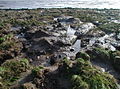
 Moonscape - geograph.org.uk - 1344173.jpg 640 × 487; 128 KB
-
 On the muddy side of Spurn - geograph.org.uk - 1515264.jpg 640 × 480; 66 KB
-
 Oxlands Bank, Skeffling - geograph.org.uk - 316557.jpg 640 × 480; 110 KB
-
 Paull Holme Strays - geograph.org.uk - 323828.jpg 640 × 427; 84 KB
-
 River Humber Saltmarsh and Mudflats - geograph.org.uk - 1084601.jpg 640 × 480; 116 KB
-
 Saltmarsh by Weeton Bank (geograph 5470244).jpg 480 × 640; 329 KB
-
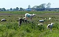 Sheep at the Welwick Saltmarsh Nature Reserve (geograph 5562258).jpg 800 × 516; 118 KB
-
 Sheep on the Welwick Saltmarsh (geograph 5562317).jpg 800 × 523; 91 KB
-
 Skeffling Clays - geograph.org.uk - 316537.jpg 486 × 640; 136 KB
-
 Sunk Island Sands - geograph.org.uk - 323851.jpg 640 × 477; 156 KB
-
 Sunk Island Sands - geograph.org.uk - 323852.jpg 640 × 479; 94 KB
-
 Sunk Island Sands - south of Newlands - geograph.org.uk - 276040.jpg 480 × 640; 116 KB
-
 The Humber - east of Hawkin's Point - geograph.org.uk - 276034.jpg 476 × 640; 127 KB
-
 The Outstray, Sunk Island - geograph.org.uk - 276030.jpg 455 × 640; 109 KB
-
 The River Humber, Sunk Island - geograph.org.uk - 297425.jpg 471 × 640; 123 KB
-
 The River Humber, Sunk Island - geograph.org.uk - 312221.jpg 640 × 477; 108 KB
-
 Towards the Humber from Brough - panoramio.jpg 3,264 × 2,448; 3.82 MB
-
 Weeton Bank (geograph 5470231).jpg 640 × 480; 312 KB
-
 Weeton Bank (geograph 5748937).jpg 640 × 480; 67 KB
-
 Welwick Saltmarsh (geograph 5470220).jpg 640 × 480; 367 KB
-
 Welwick Saltmarsh Nature Reserve (geograph 5562249).jpg 800 × 629; 144 KB
-
 Welwick Saltmarsh Nature Reserve (geograph 5562372).jpg 800 × 574; 105 KB
-
 West Bank, Sunk Island - geograph.org.uk - 297423.jpg 640 × 459; 122 KB
-
 Winsetts Clough - geograph.org.uk - 305521.jpg 640 × 473; 90 KB
-
 Wyke Bight, Spurn - geograph.org.uk - 1515226.jpg 640 × 480; 70 KB
-
 Wyke Bight, Spurn Peninsula - geograph.org.uk - 315878.jpg 640 × 480; 144 KB


.jpg)
.jpg)

.jpg)
.jpg)
.jpg)


.jpg)


.jpg)
.jpg)
.jpg)


.jpg)
.jpg)
.jpg)
.jpg)
.jpg)


