Category:Salinenkapelle (Traunstein)
Jump to navigation
Jump to search
| Object location | | View all coordinates using: OpenStreetMap |
|---|
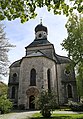
This is the category of the Bavarian Baudenkmal (cultural heritage monument) with the ID D-1-89-155-22 (Wikidata)
|
 | |||||
| Upload media | |||||
| Instance of | |||||
|---|---|---|---|---|---|
| Location | Traunstein, Upper Bavaria, Bavaria, Germany | ||||
| Street address |
| ||||
| Heritage designation | |||||
 | |||||
Subcategories
This category has only the following subcategory.
I
Media in category "Salinenkapelle (Traunstein)"
The following 11 files are in this category, out of 11 total.
-
 Karl-Theodor-Platz 1 Salinenkapelle Traunstein-1.jpg 1,914 × 2,379; 593 KB
-
 Karl-Theodor-Platz 1 Salinenkapelle Traunstein-2.jpg 1,878 × 2,541; 882 KB
-
 Karl-Theodor-Platz 1 Salinenkapelle Traunstein-3.jpg 1,887 × 2,550; 821 KB
-
 Portal St. Rupert und Maximilian Traunstein-1.jpg 3,556 × 5,075; 3.21 MB
-
 Salinenkapelle (Traunstein).jpg 3,024 × 3,803; 9.08 MB
-
 St. Rupert und Maximilian Traunstein-1.jpg 3,375 × 3,520; 2.66 MB
-
 St. Rupert und Maximilian Traunstein-2.jpg 3,563 × 5,117; 3.86 MB
-
 St. Rupert und Maximilian Traunstein-3.jpg 3,647 × 5,208; 3.45 MB
-
 St. Rupert und Maximilian Traunstein-4.jpg 3,563 × 4,865; 3.77 MB
-
 Traunstein Salinenkapelle.jpg 2,848 × 4,272; 3.67 MB
-
 TS Salinenkapelle 01.jpg 800 × 978; 220 KB


.jpg)


