Category:Sainte-Garde-des-Champs (Saint-Didier)
Jump to navigation
Jump to search
| Object location | | View all coordinates using: OpenStreetMap |
|---|
|
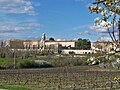
This building is inscrit au titre des monuments historiques de la France. It is indexed in the base Mérimée, a database of architectural heritage maintained by the French Ministry of Culture, under the reference PA00082148
|
convent located in Vaucluse, in France  | |||||
| Upload media | |||||
| Instance of | |||||
|---|---|---|---|---|---|
| Location | Saint-Didier, Vaucluse, Provence-Alpes-Côte d'Azur, Metropolitan France, France | ||||
| Street address |
| ||||
| Diocese | |||||
| Heritage designation |
| ||||
| official website | |||||
 | |||||
Media in category "Sainte-Garde-des-Champs (Saint-Didier)"
The following 11 files are in this category, out of 11 total.
-
 Saint Didier Sainte-Garde.jpg 953 × 640; 221 KB
-
 Saint-Didier - Couvent Sainte-Garde-des-Champs.jpg 1,824 × 1,368; 598 KB
-
 Saint-Didier 1903 Petite séminaire de Sainte-Garde.jpg 1,500 × 1,004; 763 KB
-
 Saint-Didier 1920 école de plein-air de Sainte-Garde.jpg 1,500 × 950; 480 KB
-
 Saint-Didier L'Ave Maria des séminaristes.JPG 1,500 × 955; 732 KB
-
 Saint-Didier Orphelinat laïque de Sainte-Garde en 1940.jpg 1,500 × 869; 405 KB
-
 Saint-Didier Petit séminaire de Sainte-Garde.jpg 1,500 × 945; 488 KB
-
 Saint-Didier Séminaire de Sainte Garde des Champs vers 1900.jpg 1,000 × 783; 811 KB
-
 Sainte Garde - Saint Didier.JPG 4,000 × 3,000; 2.65 MB
-
 Sainte Garde des Champs.JPG 4,000 × 3,000; 1.35 MB
-
 Vue depuis Saint Didier sur le versant sud du Mont Ventoux à droite 29 mars 2008.JPG 3,216 × 2,144; 3.13 MB


