Category:Saint Paul's Episcopal Church (Rochester, New York)
Jump to navigation
Jump to search
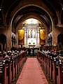
25 Westminster Road, Rochester, New York, part of the East Avenue Historic District
| Object location | | View all coordinates using: OpenStreetMap |
|---|
Media in category "Saint Paul's Episcopal Church (Rochester, New York)"
The following 10 files are in this category, out of 10 total.
-
 St. Paul's Episcopal Church, Rochester, New York.jpg 2,885 × 3,000; 2.36 MB
-
 StPaulsEpiscopalChurch2018IfMusicBeTheFoodBenefitA.jpg 3,036 × 4,048; 4.11 MB
-
 StPaulsEpiscopalChurch2018IfMusicBeTheFoodBenefitB.jpg 4,048 × 3,036; 4.93 MB
-
 StPaulsEpiscopalChurch2018IfMusicBeTheFoodBenefitC.jpg 4,048 × 3,036; 2.65 MB
-
 StPaulsEpiscopalChurch2018IfMusicBeTheFoodBenefitD.jpg 3,036 × 4,048; 2.59 MB
-
 StPaulsEpiscopalChurch2018IfMusicBeTheFoodBenefitE.jpg 3,036 × 4,048; 2.67 MB
-
 StPaulsEpiscopalChurch2018NaveLandscape.jpg 4,048 × 3,036; 4.05 MB
-
 StPaulsEpiscopalChurch2018NavePortrait.jpg 3,036 × 4,048; 3.66 MB
-
 StPaulsEpiscopalChurch2018SideChapel.jpg 3,036 × 4,048; 3.6 MB
-
 StPaulsEpiscopalChurch2018StainedGlassWindow.jpg 3,036 × 4,048; 3.41 MB


