Category:Saint Christopher church in Zloty Stok
Jump to navigation
Jump to search
| Object location | | View all coordinates using: OpenStreetMap |
|---|
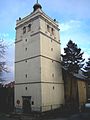
church building in Złoty Stok, Poland  | |||||
| Upload media | |||||
| Instance of | |||||
|---|---|---|---|---|---|
| Named after | |||||
| Dedicated to | |||||
| Location | Złoty Stok, Gmina Złoty Stok, Ząbkowice Śląskie County, Lower Silesian Voivodeship, Poland | ||||
| Street address |
| ||||
| Heritage designation |
| ||||
| Inception |
| ||||
 | |||||
Polski: Złoty Stok, pl. Kościelny 2 - dawny kościół ewangelicki pw. św. Krzysztofa, obecnie hala sportowa, 1545, XVII, 1785 (wieża XIV/XV)
Media in category "Saint Christopher church in Zloty Stok"
The following 16 files are in this category, out of 16 total.
-
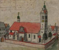 Kościół św. Krzysztofa F.B Werner XVIII wiek.png 494 × 415; 342 KB
-
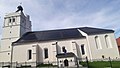 Kościół św. Krzysztofa Złoty Stok cały.jpg 3,139 × 1,766; 973 KB
-
 Kościół św. Krzysztofa Złoty Stok Wieża.jpg 1,780 × 4,032; 1.95 MB
-
 Kościół św. Krzysztofa Złoty Stok.jpg 1,513 × 2,490; 760 KB
-
 Portal Kościół św. Krzyszofa Złoty Stok.jpg 2,184 × 2,606; 1.28 MB
-
 Zloty Stok 2023 (1).jpg 2,845 × 2,134; 1.53 MB
-
 Zloty Stok 2023 (10).jpg 2,967 × 2,225; 1.79 MB
-
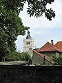 Zloty Stok 2023 (11).jpg 2,245 × 2,993; 1.81 MB
-
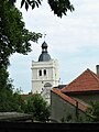 Zloty Stok 2023 (12).jpg 1,493 × 1,991; 733 KB
-
 Zloty Stok 2023 (16).jpg 562 × 422; 69 KB
-
 Zloty Stok 2023 (6).jpg 2,189 × 2,917; 1.23 MB
-
 Zloty Stok 2023 (7).jpg 2,713 × 2,035; 1.19 MB
-
 Zloty Stok 2023 (9).jpg 1,859 × 2,479; 1,000 KB
-
 Zloty Stok4.jpg 1,832 × 2,743; 1.03 MB
-
 Zloty Stok5.jpg 1,800 × 2,640; 903 KB
-
 Złoty Stok kościół ewangelicki 1.jpg 1,536 × 2,048; 496 KB


.jpg)
.jpg)
.jpg)
.jpg)
.jpg)
.jpg)
.jpg)
.jpg)

