Category:Saint-Agnant, Montierneuf priory
Jump to navigation
Jump to search
| Object location | | View all coordinates using: OpenStreetMap |
|---|
|
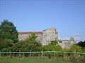
This building is en partie classé, en partie inscrit au titre des monuments historiques de la France. It is indexed in the base Mérimée, a database of architectural heritage maintained by the French Ministry of Culture, under the reference PA00105158
|
abbey located in Charente-Maritime, in France  | |||||
| Upload media | |||||
| Instance of | |||||
|---|---|---|---|---|---|
| Location | Saint-Agnant, canton of Saint-Agnant | ||||
| Has part(s) | |||||
| Heritage designation |
| ||||
 | |||||
Subcategories
This category has only the following subcategory.
Media in category "Saint-Agnant, Montierneuf priory"
The following 2 files are in this category, out of 2 total.
-
 928 - Porte du prieuré de Montierneuf - St Agnant.jpg 3,168 × 2,112; 4.51 MB
-
 Saint-Agnant2.jpg 2,048 × 1,536; 1.65 MB

