Category:Sail (Lake District)
Jump to navigation
Jump to search
English: Sail is a mountain of 773 m (2,536 ft) in the English Lake District, lying between Derwentwater and Crummock Water.
mountain in Lake District, England, UK  | |||||
| Upload media | |||||
| Instance of | |||||
|---|---|---|---|---|---|
| Location |
| ||||
| Mountain range | |||||
| Elevation above sea level |
| ||||
| Parent peak | |||||
 | |||||
Media in category "Sail (Lake District)"
The following 10 files are in this category, out of 10 total.
-
 East over to Sail - geograph.org.uk - 1490624.jpg 480 × 640; 112 KB
-
 Looking East from Sail - geograph.org.uk - 1490668.jpg 640 × 480; 96 KB
-

-
 Looking towards Sail - geograph.org.uk - 935790.jpg 640 × 480; 58 KB
-
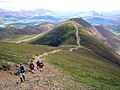
 On the Ridge to Sail - geograph.org.uk - 1490619.jpg 480 × 640; 126 KB
-
 Sail, Lake District.jpg 2,272 × 1,504; 1.64 MB
-
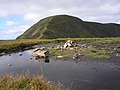
 Summit Tarn, Sail - geograph.org.uk - 501483.jpg 640 × 480; 76 KB
-
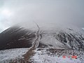
 The Summit, Sail 773m - geograph.org.uk - 1490632.jpg 640 × 480; 76 KB
-
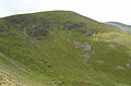
 Sail from Scar Crags - geograph.org.uk - 61809.jpg 640 × 480; 75 KB
-
 Summit of Sail - geograph.org.uk - 257067.jpg 640 × 480; 69 KB


