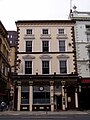
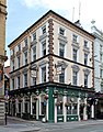
Category:Saddle Inn, Dale Street
Jump to navigation
Jump to search
| Object location | | View all coordinates using: OpenStreetMap |
|---|
pub in Liverpool, Merseyside, England, UK  | |||||
| Upload media | |||||
| Instance of | |||||
|---|---|---|---|---|---|
| Location | Liverpool, Merseyside, North West England, England | ||||
| Street address |
| ||||
| Owned by |
| ||||
| Heritage designation |
| ||||
 | |||||
Media in category "Saddle Inn, Dale Street"
The following 5 files are in this category, out of 5 total.
-
 Saddle Inn, Dale Street - geograph.org.uk - 1597686.jpg 480 × 640; 82 KB
-
 Saddle Inn, Dale Street, Liverpool.jpg 1,488 × 1,984; 632 KB
-
 The Saddle, Dale Street 2018-1.jpg 3,024 × 4,277; 6.48 MB
-
 The Saddle, Dale Street 2018-2.jpg 3,354 × 4,269; 7.58 MB
-
 The Saddle, Dale Street, Liverpool.jpg 1,532 × 1,793; 2.02 MB


