
Category:Saas-Almagell
municipality in the canton of Valais in Switzerland    | |||||
| Upload media | |||||
| Instance of | |||||
|---|---|---|---|---|---|
| Location | Visp District, Valais, Switzerland | ||||
| Located in or next to body of water | |||||
| Population |
| ||||
| Area |
| ||||
| Elevation above sea level |
| ||||
| official website | |||||
 | |||||
Subcategories
This category has the following 27 subcategories, out of 27 total.
A
- Almagellerhütte (5 F)
- Antronapass (6 F)
C
- Chessjengletscher (10 F)
F
- Furggtälli (2 F)
H
- Hinter Allalin (11 F)
- Hohlaubgletscher (4 F)
- Höhenweg Almagelleralp (11 F)
K
- Klein Allalin (10 F)
M
N
P
- Pizzo d'Andolla (10 F)
- Portjenhorn (1 F)
R
- Rimpfischhorn (93 F)
S
- Schwarzberggletscher (22 F)
- Seewjinengletscher (6 F)
- Stellihorn (14 F)
T
- Tälliboden (10 F)
W
Z
- Zwischbergenpass (5 F)
Media in category "Saas-Almagell"
The following 84 files are in this category, out of 84 total.
-
 All work and snow play.jpg 1,968 × 1,596; 617 KB
-
 Ant on flower 2.jpg 928 × 897; 237 KB
-
 Aster 4.jpg 1,223 × 1,219; 297 KB
-
 CHE Saas-Almagell Flag.svg 920 × 920; 3.38 MB
-
 CHE Saas-Almagell Logo.svg 512 × 104; 7 KB
-
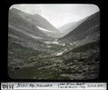
 Das Dorf Almagel im Saastal - CH-BAR - 3238951.tif 2,692 × 1,851; 1.87 MB
-
 Descending from Britanniahütte.jpg 2,424 × 1,317; 886 KB
-
 Dom, Lenzspitze, Nadelhorn bei Aufstieg zu Almageller H.jpg 4,608 × 2,592; 2.93 MB
-
 Dragonfly Sedge Hawker Aeshna juncea.jpg 2,027 × 1,376; 1.68 MB
-
 ETH-BIB-Almagellhorn-Dia 247-03071.tif 2,838 × 2,344; 6.36 MB
-
 ETH-BIB-Blauer Stein, Mattmark aufwärts-Dia 247-03136.tif 3,484 × 2,740; 9.23 MB
-
 ETH-BIB-Blauer Stein, Mattmark-Dia 247-03135.tif 3,291 × 2,799; 26.48 MB
-
 ETH-BIB-Distel-Alp, talauswärts-Dia 247-03130.tif 3,393 × 2,811; 27.4 MB
-
 ETH-BIB-Distelalp, Hüttendach mit Spaltecke talauswärts gesehen-Dia 247-03132.tif 3,388 × 2,829; 9.26 MB
-
 ETH-BIB-Distelalp-Mattmark 1822-Dia 247-08556.tif 3,720 × 2,417; 8.67 MB
-
 ETH-BIB-Lawinenwirkung Zermeiggeren-Dia 247-03001.tif 3,349 × 2,830; 9.14 MB
-
 ETH-BIB-Panorama von der Langen Fluh IX, Egginerjoch, Allalinhorn-Dia 247-03015.tif 3,382 × 2,858; 27.77 MB
-
 ETH-BIB-Panorama von der Langen Fluh, I, Portjengrat-Dia 247-03018.tif 3,291 × 2,858; 9.07 MB
-
 ETH-BIB-Panorama von der Langen Fluh, II, Almagellhorn-Dia 247-03017.tif 2,901 × 2,347; 6.51 MB
-
 ETH-BIB-Panorama von der Langen Fluh, III, Mittaghorn Egginer-Dia 247-03016.tif 3,319 × 2,849; 9.13 MB
-
 ETH-BIB-Saas-Almagell-LBS H1-024692.tif 6,089 × 4,271; 74.44 MB
-
 ETH-BIB-Schawarzberggletscher, Mischabel, Mattmark v. S.-Inlandflüge-LBS MH01-002047.tif 6,671 × 3,878; 74.17 MB
-

-
 Flag of Saas Almagell.gif 216 × 216; 7 KB
-
 Flower in Saas-Almagell.jpg 1,082 × 1,002; 371 KB
-
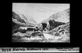
 Gewehrinspektion im Dorf Almagel - CH-BAR - 3238952.tif 1,867 × 2,740; 1.74 MB
-
 Hangende Gletscher.jpg 3,131 × 1,920; 1.62 MB
-
 Karte Gemeinde Saas Almagell 2007.png 1,476 × 1,746; 603 KB
-
 Karte Gemeinde Saas Almagell.png 767 × 907; 166 KB
-
 Kraftspiele als Pausenbeschäftigung - CH-BAR - 3238955.tif 2,740 × 1,863; 1.99 MB
-
 Lichen in Saas-Almagell.jpg 4,836 × 3,033; 4.76 MB
-
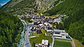
 Looking down at Saas-Almagell.jpg 4,000 × 3,000; 2.8 MB
-
 Lune sur le Mittelallalin au lever du soleil.jpg 4,256 × 2,832; 5.78 MB
-
 Ofentalbach 2.jpg 4,442 × 3,648; 5.36 MB
-
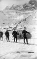 Patrouille auf Skiern - CH-BAR - 3237147.tif 3,000 × 4,762; 4.07 MB
-
 Patrouille auf Skiern - CH-BAR - 3237149.tif 3,000 × 1,932; 2.02 MB
-
 Patrouille auf Skiern - CH-BAR - 3237150.tif 3,000 × 2,029; 1.08 MB
-
 Puddle 2.jpg 6,155 × 2,899; 5.75 MB
-
 Saas Almagell von Mattmark.jpg 4,608 × 2,592; 2.95 MB
-
 Saas Almagell Wappen.jpg 129 × 148; 9 KB
-
 CHE Saas-Almagell COA.svg 500 × 600; 20 KB
-
 Saas-Almagell - glacier.jpg 3,131 × 1,906; 1.51 MB
-
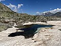
 Saas-Almagell - lake 2.jpg 5,472 × 3,648; 5.54 MB
-
 Saas-Almagell - lake 3.jpg 6,767 × 2,259; 4.13 MB
-
 Saas-Almagell - lake 4.jpg 5,472 × 3,338; 4.34 MB
-
 Saas-Almagell - lake 6.jpg 4,032 × 3,024; 4.44 MB
-
 Saas-Almagell - lake.jpg 9,540 × 3,517; 10.04 MB
-
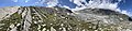
 Saas-Almagell - mountains.jpg 12,555 × 3,261; 11.92 MB
-
 Saas-Almagell - plant 2.jpg 1,114 × 1,004; 534 KB
-
 Saas-Almagell - plant.jpg 1,515 × 1,614; 737 KB
-
 Saas-Almagell 360 Grad Aufnahme.jpg 19,346 × 9,673; 65.67 MB
-
 Saas-Almagell Dorfansicht.jpg 4,000 × 2,250; 5.38 MB
-
 Saas-Almagell mountain stream.jpg 2,903 × 1,947; 2.75 MB
-
 Saas-Almagell rock formation 2.jpg 3,434 × 2,125; 2.47 MB
-
 Saas-Almagell rock formation.jpg 5,472 × 3,648; 6.33 MB
-
 Saas-Almagell.jpg 4,000 × 2,250; 4.41 MB
-
 Saasalmagell.jpg 275 × 184; 72 KB
-
 Saaser vispa.jpg 2,272 × 1,704; 1.9 MB
-
 Schwartzbergbach - bridge.jpg 5,212 × 3,306; 5.02 MB
-
 Schwartzbergbach.jpg 5,402 × 3,102; 3.22 MB
-
 Seebach.jpg 5,472 × 3,369; 6.54 MB
-
 Speicherbecken.jpg 4,000 × 2,250; 5.04 MB
-
 Stellihorn - Spähnhörner - Spechhorn.jpg 4,032 × 2,879; 3.89 MB
-
 Trail next to Mattmarksee 2.jpg 1,616 × 2,071; 1.65 MB
-
 Trail next to Mattmarksee.jpg 3,131 × 2,087; 3.39 MB
-
 Trail to Klein Allalin.jpg 5,472 × 3,648; 5.51 MB
-
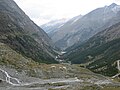 Vallée de Saas.JPG 2,592 × 1,944; 1.28 MB
-
 View to Saas-Fee - panoramio.jpg 3,072 × 2,304; 3.2 MB
-
 Wappen saas-almagell.jpg 186 × 200; 28 KB
-
 Waterfall in Saas-Almagell 2.jpg 5,472 × 3,648; 9.89 MB
-
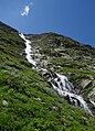 Waterfall in Saas-Almagell.jpg 3,648 × 5,057; 4.35 MB
-
 Ze Seewjinu 2.jpg 10,731 × 3,357; 10.93 MB
-
 Ze Seewjinu 3.jpg 4,032 × 2,826; 4.34 MB
-
 Ze Seewjinu trail - lake 2.jpg 16,142 × 3,788; 17.43 MB
-
 Ze Seewjinu trail - lake.jpg 14,894 × 3,642; 18.75 MB
-
 Ze Seewjinu trail - Schwarzberggrat.jpg 16,238 × 3,858; 24.71 MB
-
 Ze Seewjinu trail - snow.jpg 9,602 × 3,874; 12.65 MB
-
 Ze Seewjinu trail 2.jpg 5,472 × 3,648; 5.03 MB
-
 Ze Seewjinu trail 2024.jpg 16,168 × 3,880; 25.29 MB
-
 Ze Seewjinu trail 3.jpg 6,464 × 1,922; 4.72 MB
-
 Ze Seewjinu trail 4.jpg 12,555 × 2,631; 7.5 MB
-
 Ze Seewjinu trail and Schwartzberggrat 2.jpg 16,140 × 3,788; 23.46 MB
-
 Ze Seewjinu trail.jpg 12,555 × 2,135; 8.98 MB
-
 Ze Seewjinu.jpg 10,036 × 3,644; 11.39 MB


