Category:SVPR aeronautical charts
Jump to navigation
Jump to search
Media in category "SVPR aeronautical charts"
The following 14 files are in this category, out of 14 total.
-
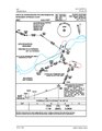
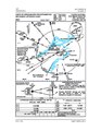
 SVPR aerodrome chart (2017).pdf 1,275 × 1,650; 285 KB
-
 SVPR aerodrome obstacles chart Tipe A (2017).pdf 1,650 × 1,275; 284 KB
-
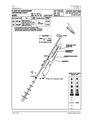
 SVPR approach chart RNP RWY 26 (2020).pdf 1,275 × 1,650, 2 pages; 1.59 MB
-
 SVPR approach chart RNP Y RWY 08 (2020).pdf 1,275 × 1,650, 2 pages; 3.33 MB
-
 SVPR approach chart RNP Z RWY 08 (2020).pdf 1,275 × 1,650, 2 pages; 3.32 MB
-
 SVPR approach chart RNP Z RWY 26 (2020).pdf 1,275 × 1,650, 2 pages; 1.31 MB
-
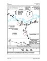
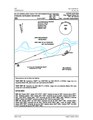
 SVPR approach chart STAR RWY 08 (2017).pdf 1,275 × 1,650, 2 pages; 376 KB
-
 SVPR approach chart VOR C (2017).pdf 956 × 1,352; 332 KB
-
 SVPR approach chart VOR-DME RWY 08 (2017).pdf 1,275 × 1,650; 426 KB
-
 SVPR departure chart CBL 1 SID RWY 08-26 (2020).pdf 1,275 × 1,650, 2 pages; 3.08 MB
-
 SVPR departure chart EPANA 1A SID RWY 08-26 (2019).pdf 1,275 × 1,650, 2 pages; 1.47 MB
-
 SVPR departure chart MIGED 1 SID RWY 08-26 (2019).pdf 1,275 × 1,650, 2 pages; 1.16 MB
-
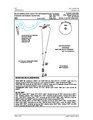
 SVPR departure chart SID RWY 08 (2018).pdf 1,275 × 1,650, 2 pages; 603 KB
-
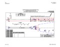
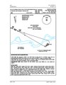
 SVPR vector guide radar chart (2017).pdf 1,650 × 1,275; 338 KB