Category:SVG maps of the history of Peru
Jump to navigation
Jump to search
Subcategories
This category has only the following subcategory.
Media in category "SVG maps of the history of Peru"
The following 34 files are in this category, out of 34 total.
-
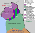
 Cuestión de Tacna y Arica.svg 3,954 × 3,837; 1.03 MB
-
 Departamento de Arica, Chile.svg 3,093 × 2,937; 787 KB
-
 Federación de los Andes.svg 2,232 × 3,260; 9.92 MB
-
 Guerra-del-pacifico-01-a.svg 349 × 612; 69 KB
-
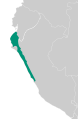
 Inca Expansion.svg 512 × 926; 134 KB
-
 Loreto (1853–1900).svg 549 × 549; 189 KB
-
 Loreto (1896).svg 549 × 549; 294 KB
-
 Map of Wari and Tiawaku.svg 267 × 365; 411 KB
-
 Map of Wari in Latin America.svg 1,000 × 1,250; 257 KB
-
 Map of Wari in Peru.svg 267 × 365; 154 KB
-
 Mapa Chimor.svg 512 × 783; 77 KB
-
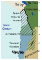 Pacifico1879-mk.svg 595 × 842; 53 KB
-
 Pacifico1879.svg 570 × 824; 51 KB
-
 Peru (1821–1851).svg 549 × 549; 259 KB
-
 Peru (1835–1836).svg 549 × 549; 360 KB
-
 Peru (1851–1883).svg 549 × 549; 226 KB
-
 Peru (1881).svg 549 × 549; 377 KB
-
 Peru (1883–1909).svg 549 × 549; 303 KB
-
 Peru (1909–1922).svg 549 × 549; 147 KB
-
 Peru (1922–1929).svg 549 × 549; 129 KB
-
 Peru (1929–1936).svg 549 × 549; 111 KB
-
 Peru (1936–1942).svg 549 × 549; 123 KB
-
 Peru - 1989 Regions (locator map, labeled, ES).svg 820 × 1,000; 1.16 MB
-
 Peru - 2011 Region proposals (locator map, labeled ES).svg 820 × 1,000; 1.17 MB
-
 Peru -2005 Region proposals (locator map, labeled ES).svg 820 × 1,000; 1.31 MB
-
 Protectorate of Peru (orthographic projection).svg 549 × 549; 355 KB
-
 Pérdidas territoriales de iure de la República de Chile.svg 1,800 × 2,808; 3.84 MB
-
 Tacna province (1884-1925) Chile location map.svg 2,268 × 2,764; 146 KB
-
 Tacna province (1925-1929) Chile location map.svg 2,268 × 2,764; 80 KB
-
 Tacna-Arica Dispute (1883-1929).svg 3,954 × 3,837; 1 MB
-
 Territorial losses of the Republic of Chile de jure.svg 1,800 × 2,808; 3.75 MB
-
 Tratado de Ancón.svg 4,591 × 6,024; 547 KB
-
 Treaty of Ancón.svg 4,606 × 6,024; 513 KB
-
 Virreinato del Perú (1810).svg 1,949 × 2,126; 7.45 MB


.svg)
.svg)


.svg)
.svg)
.svg)
.svg)
.svg)
.svg)
.svg)
.svg)
.svg)
.svg)
.svg)
.svg)
.svg)

_Chile_location_map.svg)
_Chile_location_map.svg)
.svg)


.svg)