Category:SVG maps of the Palestinian territories
Jump to navigation
Jump to search
Subcategories
This category has the following 2 subcategories, out of 2 total.
Media in category "SVG maps of the Palestinian territories"
The following 14 files are in this category, out of 14 total.
-
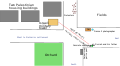 Durrah-map-en rot.svg 710 × 389; 24 KB
-
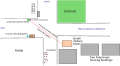 Durrah-map-en.svg 710 × 389; 22 KB
-
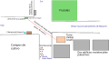 Durrah-map-es.svg 710 × 389; 20 KB
-
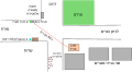 Durrah-map-he.svg 710 × 389; 29 KB
-
 GazaWestNegev.svg 2,100 × 1,360; 99 KB
-
 LocationPalestine.svg 1,000 × 500; 2.76 MB
-
 Map-Palestine 1946.svg 819 × 1,522; 146 KB
-
 Map-Palestine 1949-1967.2.svg 819 × 1,522; 185 KB
-
 Map-Palestine currently.svg 819 × 1,522; 593 KB
-
 Map-Palestine Onu resolution.svg 819 × 1,522; 160 KB
-
 Map-Palestine start.svg 819 × 1,522; 147 KB
-
 Palestina en Wikiviajes.svg 609 × 506; 734 KB
-
 Palestinian National Authority showing Israel's 1948 and 1967 borders.svg 744 × 1,052; 581 KB
-
 State of Palestine Lands and Claims.png 2,000 × 2,000; 667 KB


