Category:SVG maps of the Cook Islands
Jump to navigation
Jump to search
Countries of Oceania: Australia · Fiji · Federated States of Micronesia · Kiribati · Marshall Islands · Nauru · New Zealand · Palau · Papua New Guinea · Samoa · Solomon Islands · Tonga · Tuvalu · Vanuatu
Other areas: American Samoa · Clipperton Island · Cook Islands · French Polynesia · Guam · Hawaii · New Caledonia · Northern Mariana Islands · Wallis and Futuna – Partly: British overseas territories · Indonesia · French Southern and Antarctic Lands
Other areas: American Samoa · Clipperton Island · Cook Islands · French Polynesia · Guam · Hawaii · New Caledonia · Northern Mariana Islands · Wallis and Futuna – Partly: British overseas territories · Indonesia · French Southern and Antarctic Lands
Subcategories
This category has the following 2 subcategories, out of 2 total.
Media in category "SVG maps of the Cook Islands"
This category contains only the following file.
-
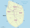 Karte Mauke.svg 865 × 828; 175 KB
