Category:SVG maps of San Andrés y Providencia Archipelago
Jump to navigation
Jump to search
Media in category "SVG maps of San Andrés y Providencia Archipelago"
The following 19 files are in this category, out of 19 total.
-
 COL orthographic (San Andrés and Providencia special).svg 550 × 550; 1.09 MB
-
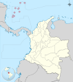 Colombia - San Andrés y Providencia.svg 2,027 × 2,294; 657 KB
-
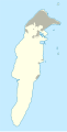
 Colombia Isla de Providencia location map (adm +urban areas).svg 1,044 × 1,457; 37 KB
-
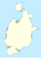
 Colombia Isla de San Andrés location map (adm +urban areas).svg 1,183 × 2,316; 48 KB
-
 Colombia Providencia Island location map.svg 1,044 × 1,457; 52 KB
-
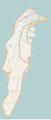
 Colombia San Andrés Island location map.svg 1,183 × 2,316; 62 KB
-
 Colombia San Andrés y Providencia location map.svg 733 × 848; 24 KB
-

-

-
 Islas de San Andrés y Providencia.svg 1,000 × 1,000; 177 KB
-
 Map of San Andres.svg 1,586 × 3,713; 942 KB
-
 Mapa A Fallo Litigio Nicaragua-Colombia.svg 1,057 × 996; 273 KB
-
 Mapa B Fallo Litigio Nicaragua-Colombia.svg 1,057 × 996; 297 KB
-
 Mapa del Archipiélago de San Andrés y Providencia.svg 1,967 × 2,303; 35 KB
-
 Rutacol-01-mapa.svg 483 × 1,174; 623 KB
-
 Rutacol-03-mapa.svg 512 × 762; 272 KB
-
 San Andrés y Providencia location map (adm +urban areas).svg 1,000 × 1,000; 97 KB
-
 San Andrés y Providencia relief location map.svg 1,000 × 1,000; 123 KB
-
 San Andrés, Providencia y Santa Catalina.svg 590 × 625; 24 KB
.svg)

.svg)
.svg)


_Course_of_the_maritime_boundary_(es).svg)
_Course_of_the_maritime_boundary.svg)


.svg)

