Category:SVG maps of Holyoke, Massachusetts
Jump to navigation
Jump to search
Media in category "SVG maps of Holyoke, Massachusetts"
The following 20 files are in this category, out of 20 total.
-

-

-
 HolyokeMA neighborhoods.svg 501 × 828; 25 KB
-
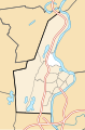
 USA Holyoke location map Churchill highlighted.svg 176 × 266; 204 KB
-
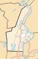
 USA Holyoke location map Downtown highlighted.svg 176 × 266; 204 KB
-
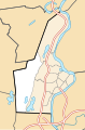
 USA Holyoke location map Elmwood highlighted.svg 176 × 266; 204 KB
-
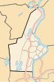
 USA Holyoke location map Highland Park highlighted.svg 176 × 266; 204 KB
-
 USA Holyoke location map Highlands highlighted.svg 176 × 266; 204 KB
-
 USA Holyoke location map Homestead Avenue highlighted.svg 176 × 266; 204 KB
-
 USA Holyoke location map Ingleside highlighted.svg 176 × 266; 204 KB
-
 USA Holyoke location map Jarvis Avenue highlighted.svg 176 × 266; 204 KB
-
 USA Holyoke location map lg.svg 176 × 266; 314 KB
-
 USA Holyoke location map Oakdale highlighted.svg 176 × 266; 204 KB
-
 USA Holyoke location map Rock Valley highlighted.svg 176 × 266; 204 KB
-
 USA Holyoke location map Smiths Ferry highlighted.svg 176 × 266; 204 KB
-
 USA Holyoke location map South Holyoke highlighted.svg 176 × 266; 204 KB
-
 USA Holyoke location map Springdale highlighted.svg 176 × 266; 204 KB
-
 USA Holyoke location map The Flats highlighted.svg 176 × 266; 204 KB
-
 USA Holyoke location map Whiting Farms highlighted.svg 176 × 266; 204 KB
-
 USA Holyoke location map.svg 176 × 266; 205 KB


