Category:SVG maps of Colombia
Jump to navigation
Jump to search
Countries of the Americas: Antigua and Barbuda · Argentina · The Bahamas · Barbados · Belize · Bolivia · Brazil · Canada · Chile · Colombia · Costa Rica · Cuba · Dominica · Dominican Republic · Ecuador · El Salvador · Grenada · Guatemala · Guyana · Haiti · Honduras · Jamaica · Mexico · Nicaragua · Panama · Paraguay · Peru · Saint Kitts and Nevis · Saint Lucia · Saint Vincent and the Grenadines · Suriname · Trinidad and Tobago · United States of America · Uruguay · Venezuela
Other areas: Anguilla · Aruba · Bermuda · British Virgin Islands · Cayman Islands · Curaçao · Dutch Caribbean · French Guiana · Greenland · Guadeloupe · Martinique · Puerto Rico · Saint Barthélemy · Saint-Martin · Saint Pierre and Miquelon · Sint Maarten
Other areas: Anguilla · Aruba · Bermuda · British Virgin Islands · Cayman Islands · Curaçao · Dutch Caribbean · French Guiana · Greenland · Guadeloupe · Martinique · Puerto Rico · Saint Barthélemy · Saint-Martin · Saint Pierre and Miquelon · Sint Maarten
Subcategories
This category has the following 20 subcategories, out of 20 total.
*
- SVG maps of islands of Colombia (17 F)
B
- SVG maps of borders of Colombia (27 F)
C
D
E
F
- SVG flag maps of Colombia (11 F)
H
L
P
- SVG pipeline maps of Colombia (16 F)
R
- SVG maps of rivers of Colombia (13 F)
- SVG maps of regions of Colombia (18 F)
S
T
Media in category "SVG maps of Colombia"
The following 30 files are in this category, out of 30 total.
-
 Airport ADZ - route.svg 986 × 1,424; 167 KB
-
 Ambito cumbia.svg 933 × 701; 506 KB
-
 Caribbean maritime boundaries map zh.svg 3,561 × 2,221; 2.87 MB
-
 Caribbean maritime boundaries map.svg 3,561 × 2,221; 2.78 MB
-
 Caribbean maritime boundaries map mk.svg 3,561 × 2,221; 5.52 MB
-
 Mapa das Caraíbas (fronteiras marítimas).svg 3,561 × 2,221; 2.86 MB
-
 Mapa del Caribe (límites marinos).svg 5,340 × 3,660; 3.02 MB
-
 Mapa del Mar Caribe (límites marinos)-fr.svg 3,587 × 2,221; 1.91 MB
-
 Mapa del Mar Caribe (límites marinos).svg 3,587 × 2,221; 1.98 MB
-
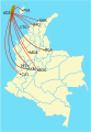
 Cartafueyu de los vuelos dende Cali.svg 924 × 1,291; 256 KB
-
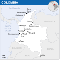 Colombia - Location Map (2013) - COL - UNOCHA.svg 254 × 254; 312 KB
-
 Colombia disputed w1 countrymap.svg 1,000 × 1,000; 37 KB
-
 Colombia Mapa Oficial.svg 2,072 × 2,339; 3.58 MB
-
 Colombia protestas.svg 125 × 98; 10 KB
-
 Colombia svg.svg 512 × 689; 762 KB
-
 Colombia svg3.svg 512 × 689; 754 KB
-
 Colombia2 svg.svg 512 × 689; 754 KB
-
 H1N1 Colombia map by confirmed cases.svg 986 × 1,424; 140 KB
-
 H1N1 Colombia map by confirmed deaths.svg 986 × 1,424; 138 KB
-
 H1N1 Colombia map.svg 986 × 1,424; 140 KB
-
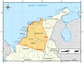
 LaGuajiraMunicipios.svg 744 × 1,052; 26 KB
-
 Lazo Negro Colombia.svg 100 × 137; 9 KB
-
 Map of major Colombian volcanoes-es.svg 480 × 480; 160 KB
-
 Map of major Colombian volcanoes.svg 480 × 480; 171 KB
-
 Mapa da Colômbia (OCHA).svg 254 × 254; 263 KB
-
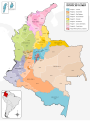 Mapa de Colombia (Regiones de la Policia Nacional).svg 1,420 × 1,896; 1.06 MB
-
 Mapa del Mar de Balboa (límites marinos).svg 2,177 × 2,006; 530 KB
-
 Mapa Diocesis de Colombia.svg 2,027 × 2,294; 1.64 MB
-
 Nueva Gran Colombia.svg 439 × 294; 164 KB
-
 User-jyon-places-visited.svg 512 × 692; 404 KB


.svg)
.svg)
-fr.svg)
.svg)

_-_COL_-_UNOCHA.svg)


.svg)
.svg)
.svg)


