Category:SVG locator maps of tehsils of Birbhum
Jump to navigation
Jump to search
Media in category "SVG locator maps of tehsils of Birbhum"
The following 19 files are in this category, out of 19 total.
-
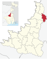
 Bolpur Sriniketan in Birbhum (West Bengal).svg 512 × 642; 462 KB
-
 Dubrajpur in Birbhum (West Bengal).svg 512 × 642; 462 KB
-
 Illambazar in Birbhum (West Bengal).svg 512 × 642; 462 KB
-
 Khoyrasol in Birbhum (West Bengal).svg 512 × 642; 462 KB
-
 Labpur in Birbhum (West Bengal).svg 512 × 642; 462 KB
-
 Mayureswar-I in Birbhum (West Bengal).svg 512 × 642; 462 KB
-
 Mayureswar-II in Birbhum (West Bengal).svg 512 × 642; 462 KB
-
 Mohammad Bazar in Birbhum (West Bengal).svg 512 × 642; 462 KB
-
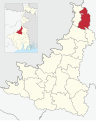
 Murarai-I in Birbhum (West Bengal).svg 512 × 642; 462 KB
-
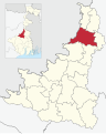
 Murarai-II in Birbhum (West Bengal).svg 512 × 642; 462 KB
-
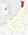
 Nalhati-I in Birbhum (West Bengal).svg 512 × 642; 462 KB
-
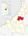
 Nalhati-II in Birbhum (West Bengal).svg 512 × 642; 449 KB
-
 Nanoor in Birbhum (West Bengal).svg 512 × 642; 462 KB
-
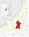
 Rajnagar in Birbhum (West Bengal).svg 512 × 642; 462 KB
-
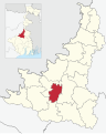
 Rampurhat-I in Birbhum (West Bengal).svg 512 × 642; 462 KB
-
 Rampurhat-II in Birbhum (West Bengal).svg 512 × 642; 462 KB
-
 Sainthia in Birbhum (West Bengal).svg 512 × 642; 462 KB
-
 Suri-I in Birbhum (West Bengal).svg 512 × 642; 462 KB
-
 Suri-II in Birbhum (West Bengal).svg 512 × 642; 462 KB
.svg)
.svg)
.svg)
.svg)
.svg)
.svg)
.svg)
.svg)
.svg)
.svg)
.svg)
.svg)
.svg)
.svg)
.svg)
.svg)
.svg)
.svg)
.svg)