Category:SVG locator maps of departments of Uruguay
Jump to navigation
Jump to search
English: SVG locator maps for Uruguayan departments and their capitals
Nederlands: SVG kaartjes voor Uruguayaanse departementen en hun hoofdsteden
Subcategories
This category has only the following subcategory.
Media in category "SVG locator maps of departments of Uruguay"
The following 22 files are in this category, out of 22 total.
-
 Departments of Uruguay.svg 904 × 1,004; 98 KB
-
 Uruguay departments blank.svg 904 × 1,004; 95 KB
-
 Uruguay departments.svg 904 × 1,004; 107 KB
-
 Uruguay-Artigas.svg 908 × 1,004; 96 KB
-
 Uruguay-Canelones.svg 908 × 1,004; 96 KB
-
 Uruguay-Cerro Largo.svg 908 × 1,004; 96 KB
-
 Uruguay-Colonia.svg 908 × 1,004; 96 KB
-
 Uruguay-Durazno.svg 908 × 1,004; 96 KB
-
 Uruguay-Flores.svg 908 × 1,004; 96 KB
-
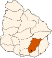
 Uruguay-Florida.svg 908 × 1,004; 96 KB
-
 Uruguay-Lavalleja.svg 908 × 1,004; 96 KB
-
 Uruguay-Maldonado.svg 908 × 1,004; 96 KB
-
 Uruguay-Montevideo.svg 908 × 1,004; 96 KB
-
 Uruguay-Paysandú.svg 908 × 1,004; 96 KB
-
 Uruguay-Rivera.svg 908 × 1,004; 96 KB
-
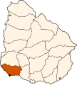
 Uruguay-Rocha.svg 908 × 1,004; 96 KB
-
 Uruguay-Río Negro.svg 908 × 1,004; 96 KB
-
 Uruguay-Salto.svg 908 × 1,004; 96 KB
-
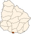
 Uruguay-San José.svg 908 × 1,004; 96 KB
-
 Uruguay-Soriano.svg 908 × 1,004; 96 KB
-
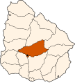
 Uruguay-Tacuarembó.svg 908 × 1,004; 96 KB
-
 Uruguay-Treinta y Tres.svg 908 × 1,004; 96 KB


