Category:SKH St. Luke's Settlement Neighbourhood Elderly Centre
Jump to navigation
Jump to search
| Object location | | View all coordinates using: OpenStreetMap |
|---|
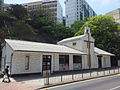
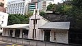
中文:聖公會聖路加堂牧民中心
English: St. Luke's Chapel was built by St. Luke's Church Settlement in 1951. With the approval and funding from the Social Welfare Department, the Settlement converted the building into an elderly centre in October 1979. Presently named as Sheung Kung Hui St. Luke's Settlement Neighborhood Elderly Centre.
Media in category "SKH St. Luke's Settlement Neighbourhood Elderly Centre"
The following 7 files are in this category, out of 7 total.
-
 47 Victoria Road 2012.jpg 1,600 × 1,200; 414 KB
-
 Hong Kong (27637349383).jpg 3,721 × 2,444; 1.29 MB
-
 Kennedy Town Jockey Club Clinic 2012 01.jpg 1,600 × 1,200; 386 KB
-
 Kennedy Town, Hong Kong - panoramio (6).jpg 3,840 × 2,160; 3.72 MB
-
 KennedyTownJockeyClubClinic.JPG 1,424 × 1,068; 270 KB
-
 Victoria Road, Hong Kong 01.jpg 2,560 × 1,536; 1.5 MB
-
 聖公會聖路加堂牧民中心.jpg 1,006 × 480; 110 KB

.jpg)

.jpg)


