Category:Sägemühle (Bir Sagi 1, Saxeten)
Jump to navigation
Jump to search
| Object location | | View all coordinates using: OpenStreetMap |
|---|
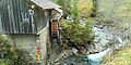
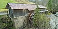
Sawmill building in Saxeten in the canton of Bern, Switzerland   | |||||
| Upload media | |||||
| Instance of | |||||
|---|---|---|---|---|---|
| Part of | |||||
| Location | Saxeten, Interlaken-Oberhasli administrative district, Oberland administrative region, Bern, Switzerland | ||||
| Located in or next to body of water | |||||
| Street address |
| ||||
| Heritage designation |
| ||||
| Inception |
| ||||
 | |||||
Media in category "Sägemühle (Bir Sagi 1, Saxeten)"
The following 4 files are in this category, out of 4 total.
-
 Saxeten - Sägemühle 01.jpg 3,168 × 1,584; 1.34 MB
-
 Saxeten - Sägemühle 02.jpg 3,168 × 1,584; 3.29 MB
-
 Saxeten - Sägemühle 03.jpg 3,168 × 1,584; 4.35 MB
-
 Saxeten - Sägemühle 04.jpg 3,168 × 1,584; 4.64 MB

