Category:Ryumonji (Manazuru)
Jump to navigation
Jump to search
| Object location | | View all coordinates using: OpenStreetMap |
|---|
 | |||||
| Upload media | |||||
| Instance of | |||||
|---|---|---|---|---|---|
| Named after | |||||
| Location | Iwa, Manazuru, Seisho | ||||
| Religion or worldview | |||||
 | |||||
Media in category "Ryumonji (Manazuru)"
The following 6 files are in this category, out of 6 total.
-
 五層塔と頌徳碑.jpg 3,024 × 4,032; 5.3 MB
-
 宝篋印塔 真鶴町.jpg 4,032 × 3,024; 5.19 MB
-
 真鶴町龍門寺山門.jpg 3,024 × 4,032; 4.16 MB
-
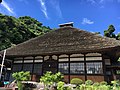
 真鶴町龍門寺庫裏.jpg 4,032 × 3,024; 3.38 MB
-
 真鶴町龍門寺本堂.jpg 4,032 × 3,024; 3.64 MB
-
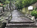 龍門寺山門前.jpg 4,032 × 3,024; 5.68 MB


