Category:Rynek 17 tenement house in Lublin
Jump to navigation
Jump to search
| Object location | | View all coordinates using: OpenStreetMap |
|---|
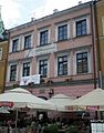
Polski: Lublin, Rynek 17 - kamienica, XV, XVI, XIX, 1948-1952
  | |||||
| Upload media | |||||
| Instance of | |||||
|---|---|---|---|---|---|
| Location | Lublin, Lublin Voivodeship, Poland | ||||
| Heritage designation | |||||
 | |||||
Media in category "Rynek 17 tenement house in Lublin"
The following 13 files are in this category, out of 13 total.
-
 A491 kamienica Rynek 17 Lublin.jpg 2,304 × 3,456; 3.2 MB
-
 Kamienica Wieniawskiego A 123.JPG 3,648 × 2,736; 3.69 MB
-
 Lublin Rynek 17 01.JPG 3,000 × 4,000; 4.25 MB
-
 Lublin Rynek 17 02.JPG 3,000 × 4,000; 3.92 MB
-
 Lublin Rynek 17 03.jpg 1,768 × 1,288; 1.1 MB
-
 Lublin Rynek 17 04.jpg 1,768 × 1,176; 1.2 MB
-
 Lublin Rynek 17, kamienica.jpg 1,000 × 1,507; 1.22 MB
-
 Lublin, Kamienica Wieniawskich - fotopolska.eu (253545).jpg 800 × 1,200; 201 KB
-
 PL Lublin Rynek 17 kamienica1.jpg 1,046 × 689; 511 KB
-
 PL Lublin Rynek 17 kamienica2.jpg 1,495 × 1,916; 1.88 MB
-
 Tablica Ignacy Baranowski-urodzenie-rynek17-Lublin.JPG 3,648 × 2,736; 3.5 MB
-
 Tablica Wieniawskiego-urodzenia.JPG 3,648 × 2,736; 3.29 MB
-
 Lublin. Zniszczenia na rynku (2-236).jpg 2,448 × 3,520; 616 KB


.jpg)


.jpg)